
How We Can Help You
High-quality visuals are a must for delivering your message. Whether you are starting from a detailed diagram that needs only a few adjustments to be perfect, a doodle sketched on a napkin, or any point between, our graphic designers and artists bring your ideas and data to life.
We create a variety of images—maps, data interpretations, infographics, illustrations, photos, and more—that that can be tailored to any format of hard copy or electronic media. Consulting on publication design and layout is available. Universal design principles can be accommodated to make your product accessible to the widest audience possible.
Communication with clients is the first step in producing a great visual. Our designers and artists will meet with you to discuss your needs and then keep you in the loop during the creative process. Whether you know exactly what you want at the beginning or are giving us ideas as a starting point, we draw on years of experience with archaeology, history, geography, and data presentation to deliver on your project.
Maps, graphics, artistic reconstructions, and illustrations tailored to any format:
- Research and academic journals, technical reports, and professional papers
- Dissertations and theses
- Book figures
- Annual reports
- Newsletters
- Popular publications
- Website images
- PowerPoint presentations
- Signage
- Visitor’s guides
- Posters
- Restoration and enhancement of photographs and slides
Explore our graphic services
To learn more about what we can do for you and how we do it, explore the other sections on this page, and then visit our blog to read about Rob Ciaccio’s archaeological reconstructions.
Contracting information
Please contact us to commission new graphics or request permission to reuse existing images.
Aerial Photography
Aerial photography provides invaluable documentary data, as well as being one of the best tools available for communicating to a variety of audiences. We provide cost-effective, high-resolution aerial photography of job sites, archaeological sites, survey areas, and project areas.
Photographs are tailored to the individual needs of the project for use in project planning, project reports, professional presentations, communication with the public and project sponsors, and promotional material. We work from the platform (helicopter, fixed wing crewed aircraft, or UAV) that best suits client needs and have the equipment to provide outstanding image quality.
Henry D. Wallace has 30 years of photography experience. His images have been published in a wide range of publications, including the Arizona Daily Star newspaper, books, magazines, and many professional reports.
Caleb Ferbrache is an FAA certified remote airman. All remote flight missions comply with Part 107 of the Federal Aviation Regulations governing commercial UAV use.
Services include:
- High-resolution oblique aerial photography
- High-resolution vertical photography
- Helicopter, fixed-wing, UAV platforms
Gallery (click to enlarge and zoom)
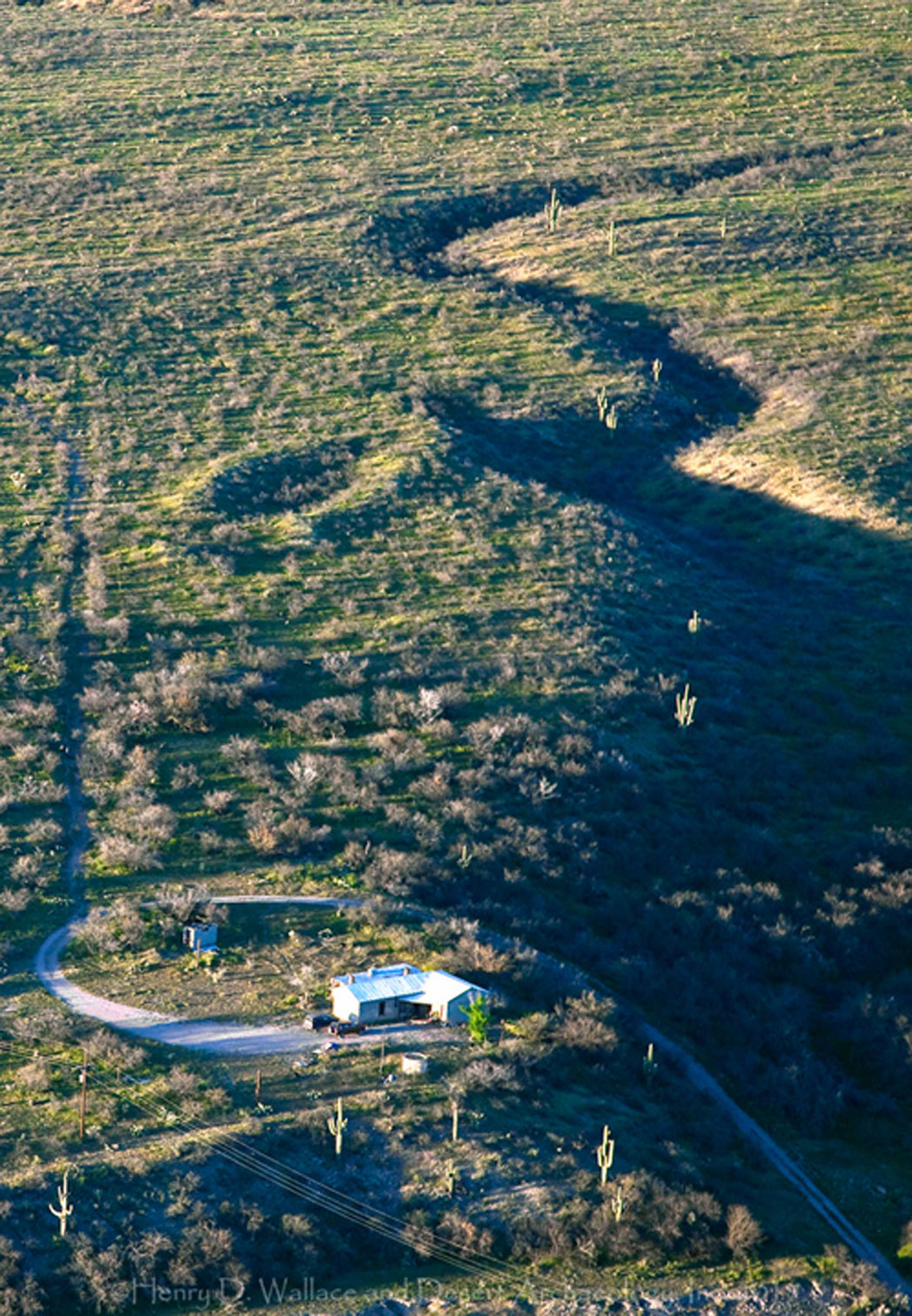
Dramatic Hohokam ballcourt in the San Pedro Valley, Arizona, dwarfs nearby ranch house (by Henry Wallace).

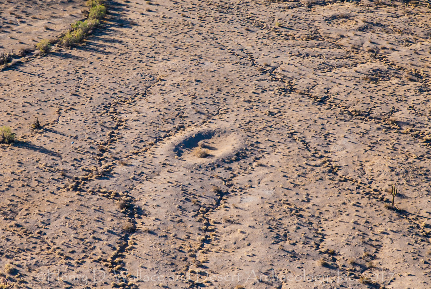
2,500 year old agricultural field system (marked with paint) at Las Capas in Tucson (by Henry Wallace).

Early Agricultural period (circa 800 B.C.) pithouse foundations in downtown Tucson beneath an old parking lot (by Henry Wallace).

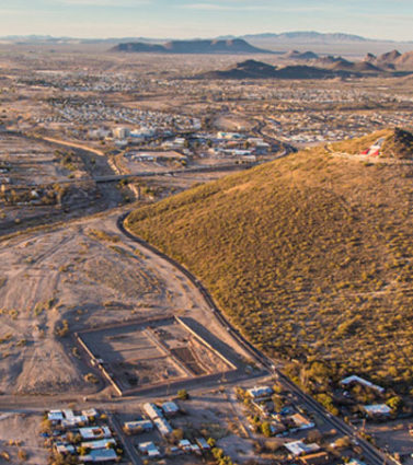
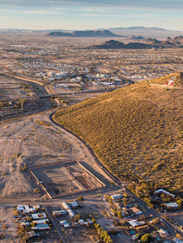
The I-10/Santa Cruz River Corridor through the northern Tucson Basin (by Henry Wallace).
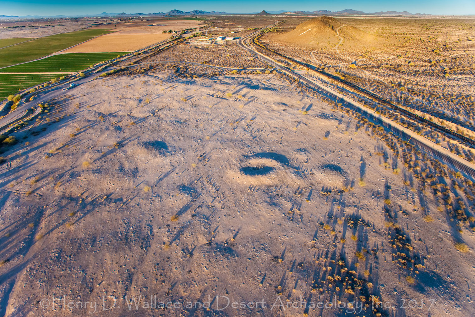
A portion of a very large Hohokam rock art site near Picacho (by Henry Wallace).
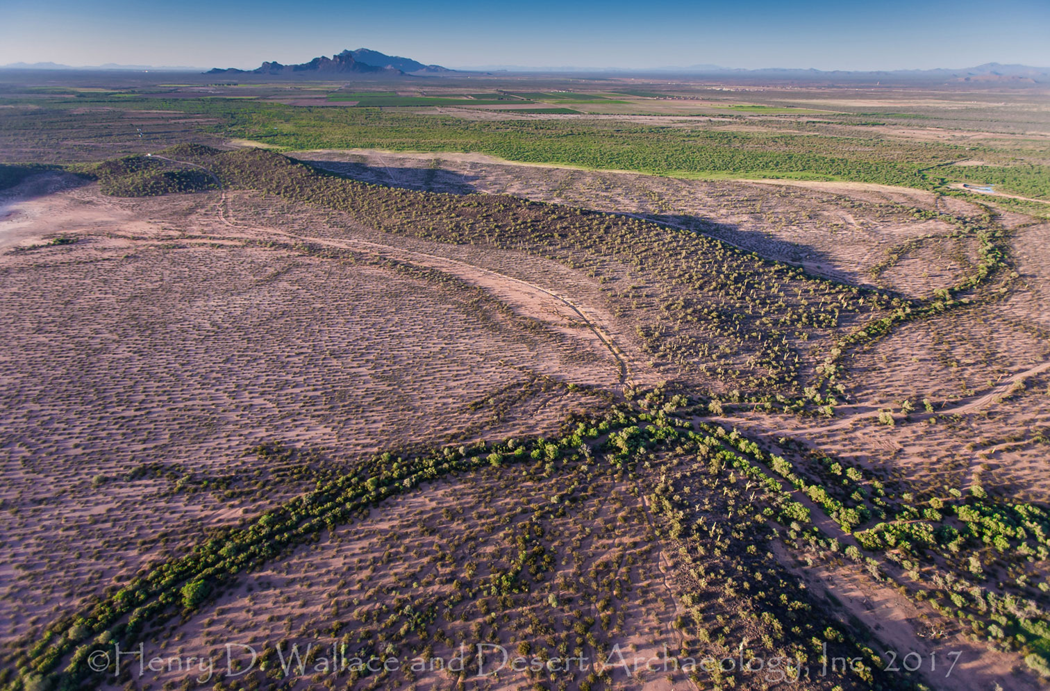
Unexcavated ancient Hohokam ballcourt on a village site near Gila Bend, Arizona (by Henry Wallace).
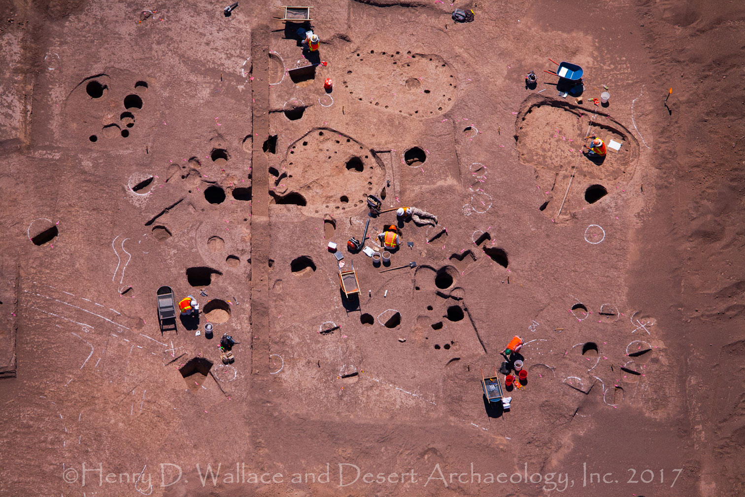
Residential locus at the 3,000-year-old Las Capas site excavated by Desert Archaeology for Pima County as part of improvements made at the Ina Road wastewater treatment facility in Tucson (by Henry Wallace).
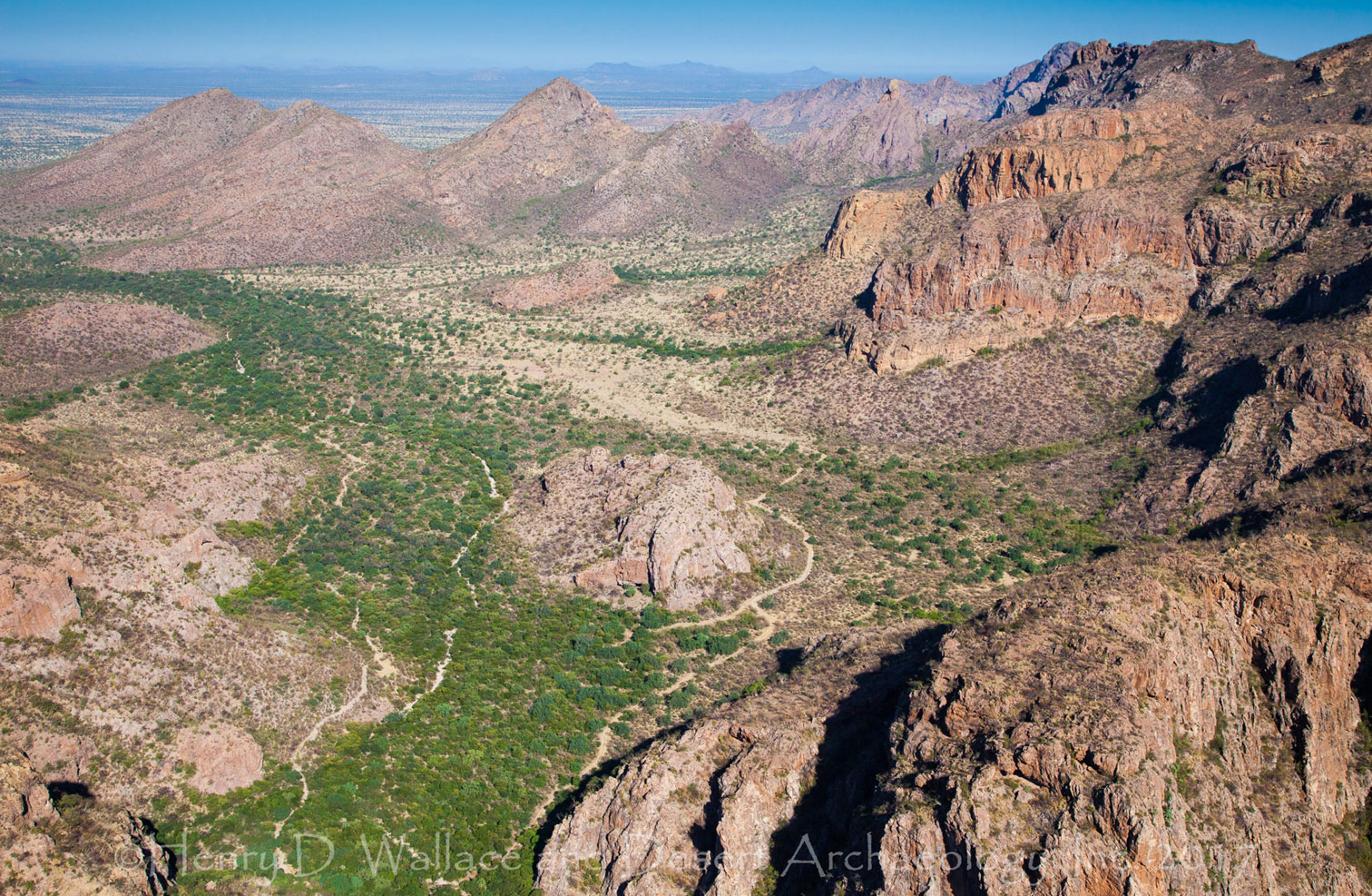
Locus of Paleoindian (10,000-12,000 years ago) occupation in a canyon in central Sonora, Mexico (by Henry Wallace).
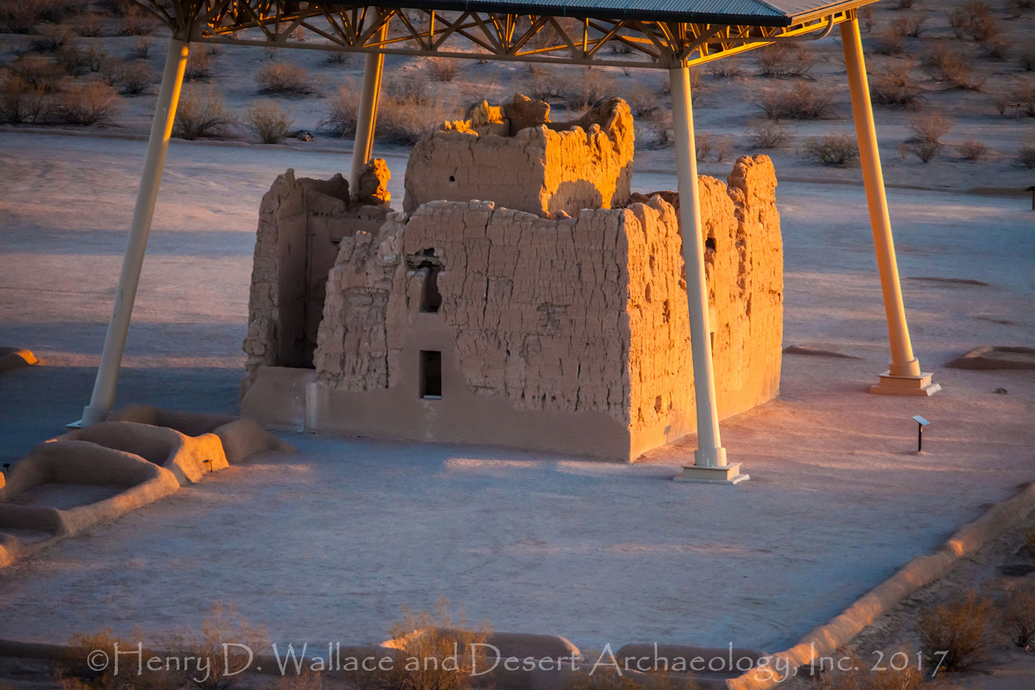
Low-level aerial photograph of the Big House at Casa Grande Ruins National Monument, Arizona (by Henry Wallace).
Large Hohokam village near Florence, Arizona. Note the ballcourt near the center of the image (by Henry Wallace).
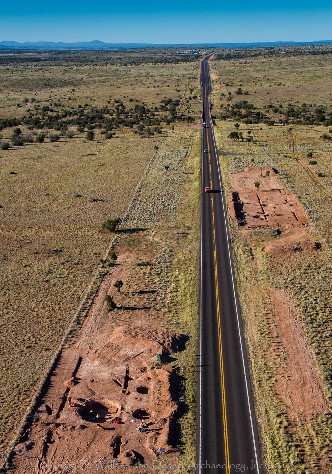
Basketmaker village excavated by Desert Archaeology, Inc. for ADOT in advance of improvements being made to the highway north of Snowflake, Arizona (by Henry Wallace).
Contracting information:
Please contact us to commission photography or to discuss the fees and permissions for reuse of existing photos.
Interpretive Graphics
Artists Robert B. Ciaccio and Eric Carlson create vivid reconstructions of past lifeways based on environmental, architectural, biological, and material cultural data.
Interpretive Graphics
Artists Robert B. Ciaccio and Eric Carlson create vivid reconstructions of past lifeways based on environmental, architectural, biological, and material cultural data. Reconstructed individual appearances and domestic scenes translate research on the lifeways of past peoples to any audience in an intuitive and approachable manner.
Images of individuals put faces to the people of the past. Illustrations of prehistoric structures show architectural details and can depict construction sequences. Scenes of daily life present a comprehensive picture of how people interacted with each other, their technology, their built environment, and their natural setting.
This unique type of artwork is ideal for websites, book covers, frontispieces, foldouts, posters, and signage. The graphic artistic process is driven by research and collaboration with subject matter experts to deliver on the client’s vision. See more about Rob Ciaccio’s work here.
Contact us to contract graphic services or to inquire about licensing fees for existing artwork.
Gallery (click to enlarge and zoom)
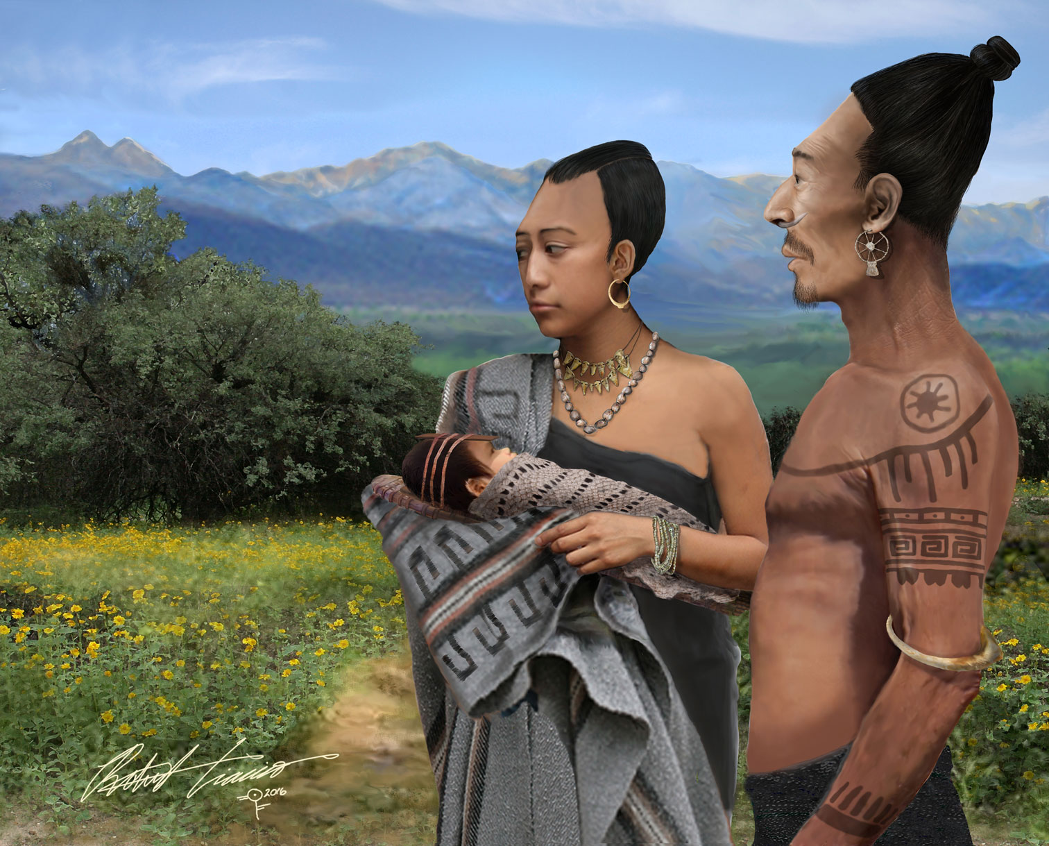
Depiction of members of a pre-Hispanic family, all displaying tabular oblique cranial modification. This image is based on individuals from the El Cementerio site, located along the middle Rio Yaqui in central Sonora, Mexico. This image is featured in Archaeology Southwest Magazine (Vol. 30, No. 3), as well as an exhibit in the Instituto Nacional de Antropología y Historia, Sonora (by Robert Ciaccio).
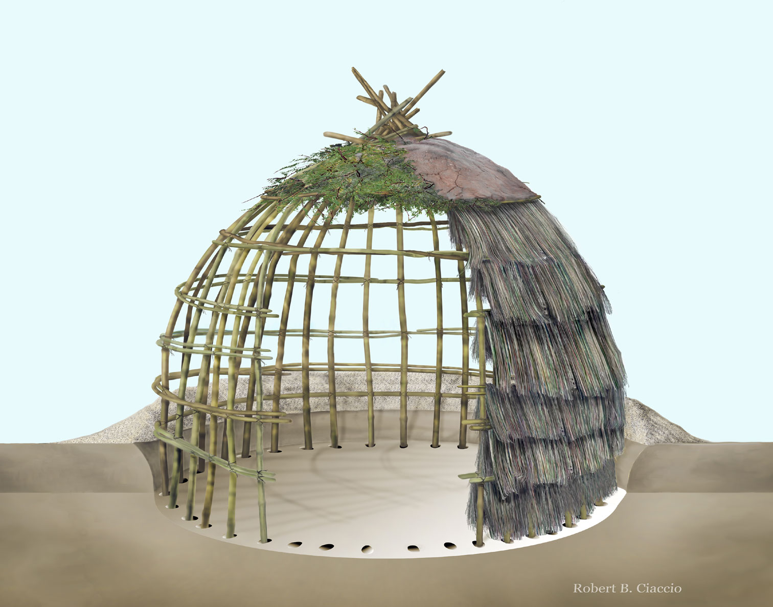
Cutaway view of an Early Agricultural period pithouse (by Robert Ciaccio).
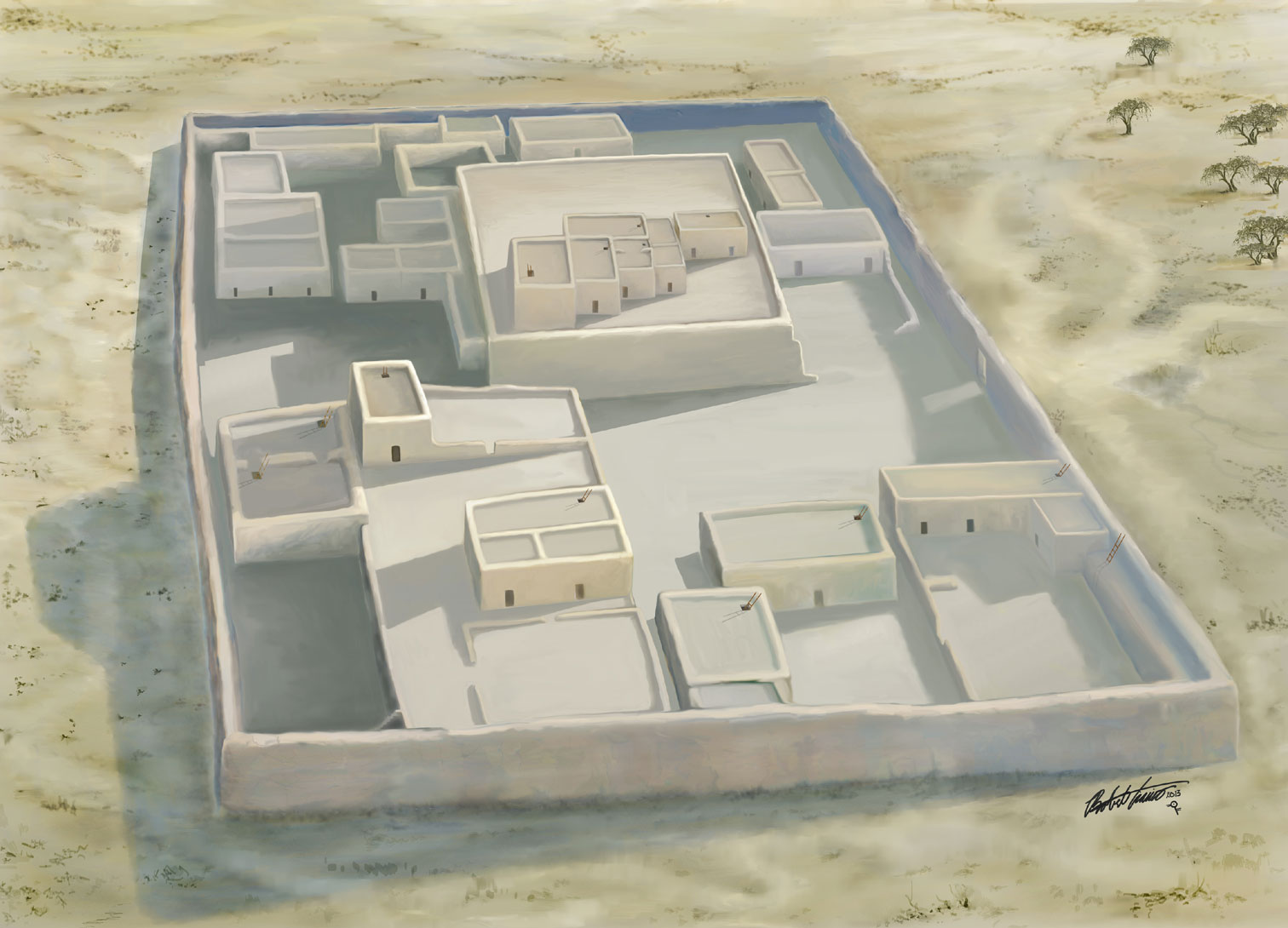
Architectural reconstruction of a platform mound surrounded by a 7-foot wall, for Casa Grande Ruins Wayside # 13, “Earthen Platform Mounds” (by Robert Ciaccio).

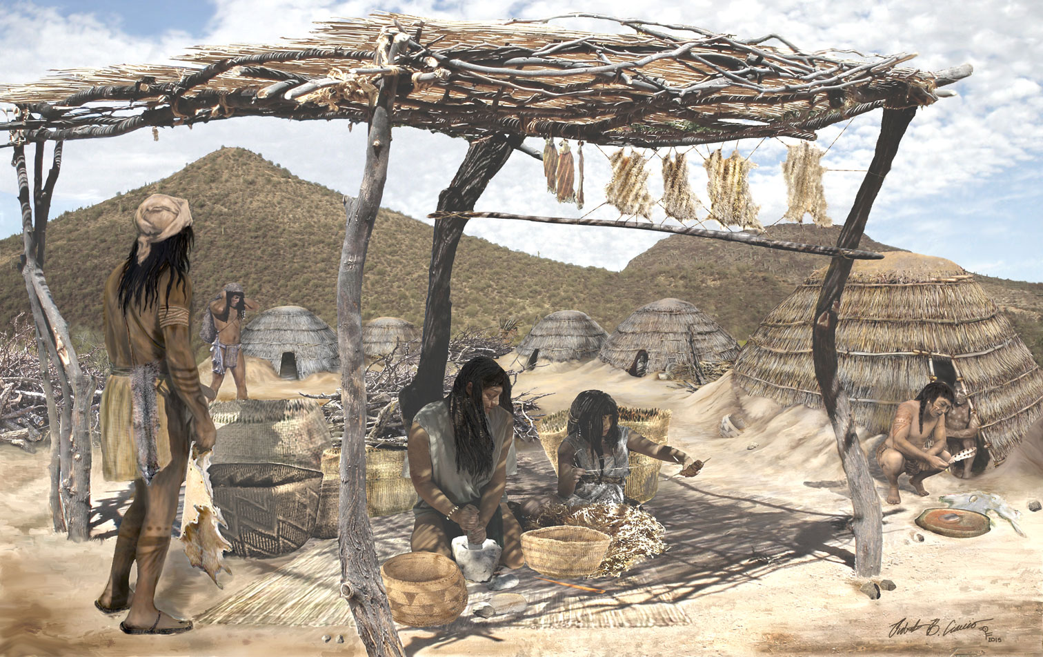
Reconstruction of a moment in time at Honey Bee Village, a Hohokam settlement occupied between A.D.850 and 1000, for Archaeology Southwest Magazine (Vol. 27, No. 1) (by Robert Ciaccio).
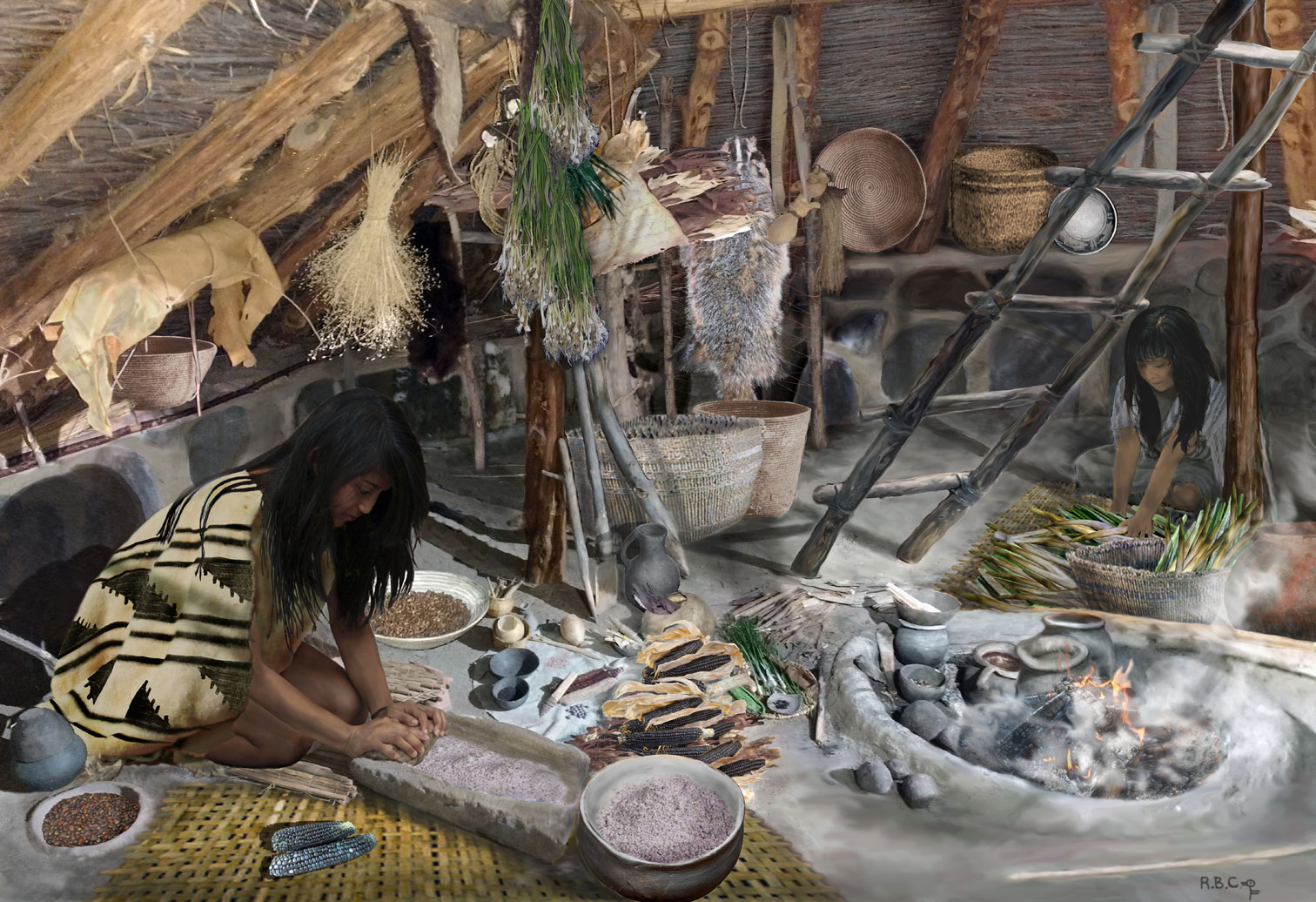
Scene of food preparation and storage by the Fremont people, for Archaeology Southwest Magazine (Vol. 29, No. 4) (by Robert Ciaccio).
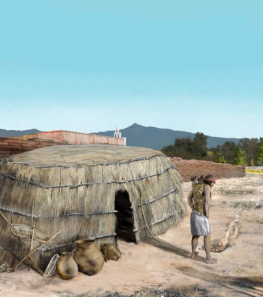
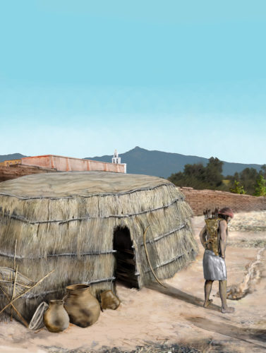
Scene of village life in an Early Agricultural period settlement at the base of Tucson’s A-Mountain (by Robert Ciaccio).

Depiction of an Early Agricultural period couple building a pithouse at the base of Sentinel Peak (A-Mountain) in Tucson (by Robert Ciaccio).
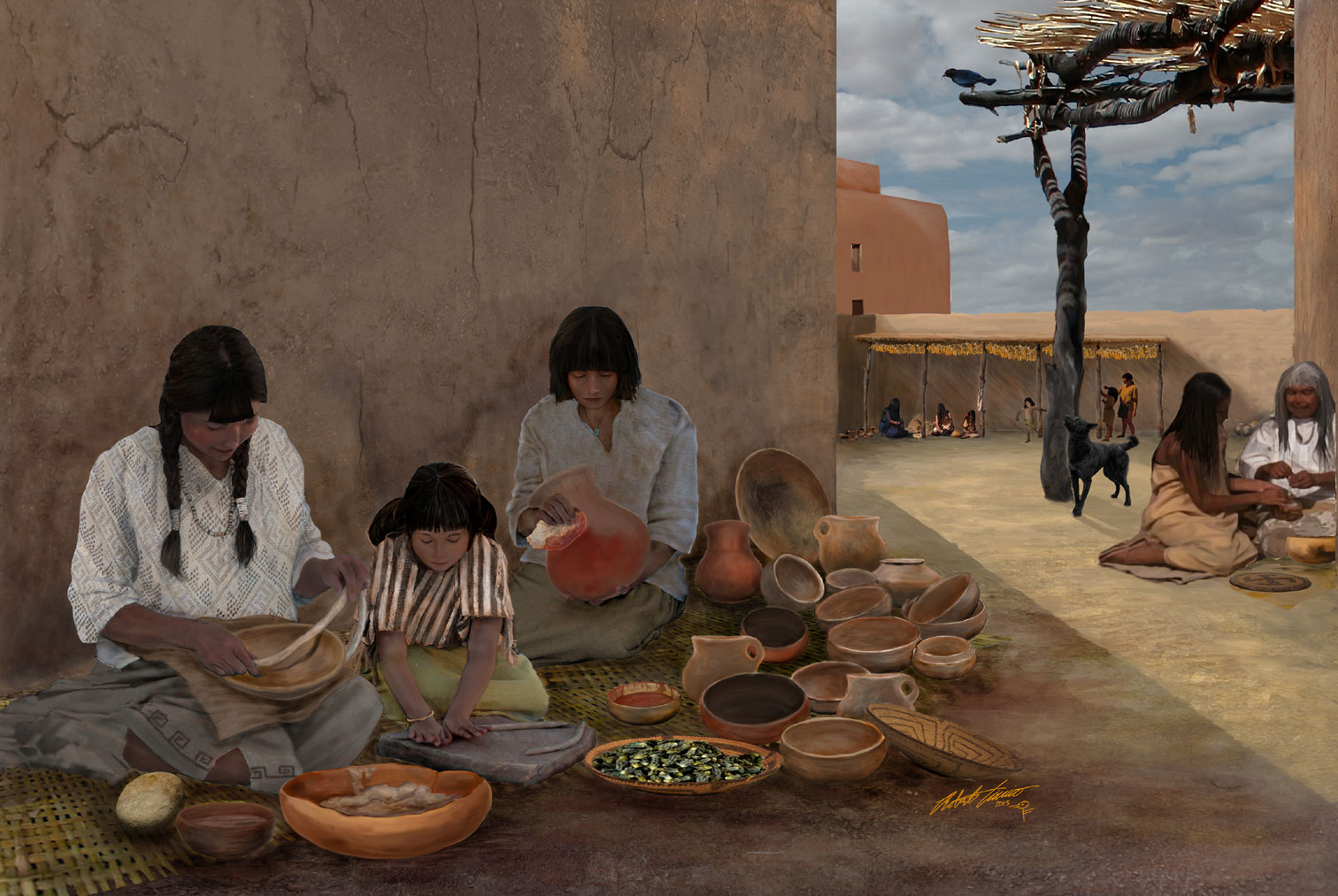
Reconstructed domestic scene for a signage project at Casa Grande Ruins National Monument: Wayside #4, “Daily Life Within the Walls” (by Robert Ciaccio).

Reconstruction of artisans at work and other activities occurring within the lively plaza at Casa Grande, for Casa Grande Ruins Wayside #9, “Not Just Survival—A Place for the Arts” (by Robert Ciaccio).
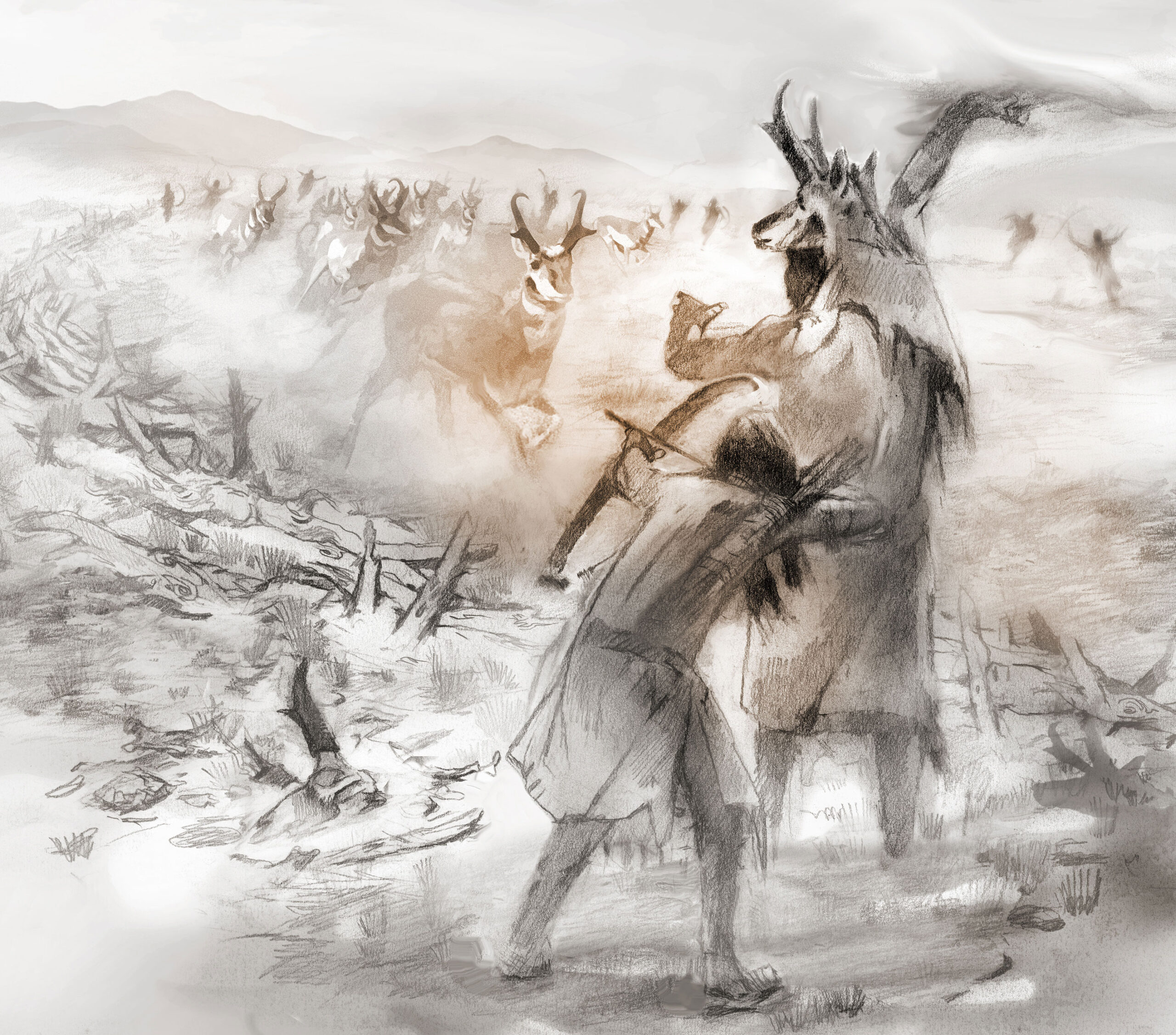
Antelope shaman and pronghorn driveline (published in First Peoples of the Great Salt Lake: A Cultural Landscape from Nevada to Wyoming, by Steven R. Simms, 2023 University of Utah Press)(by Eric Carlson).
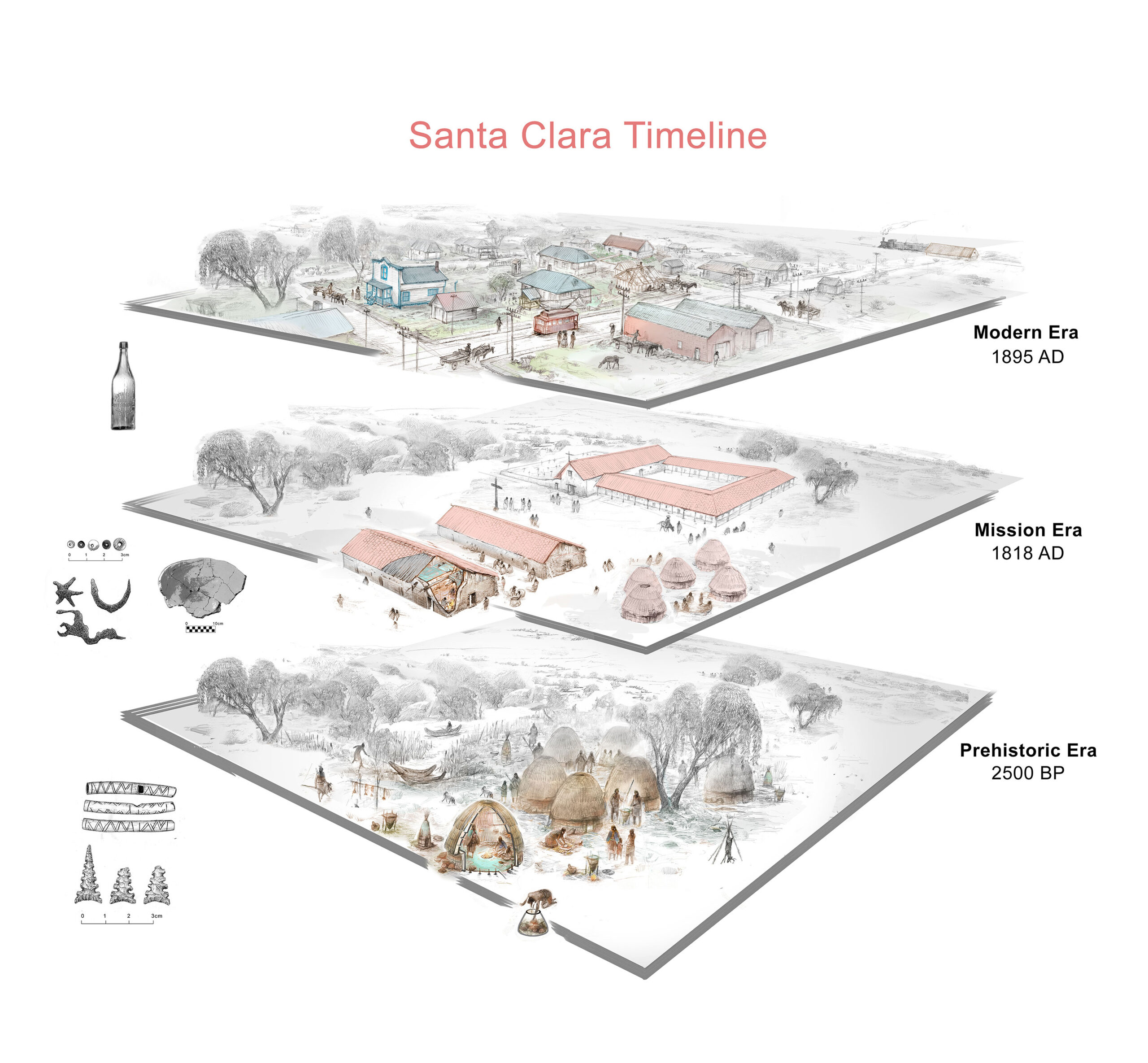
Stacked timeline depicting the dynamic cultural landscape around and beneath Santa Clara College, CA (by Eric Carlson).
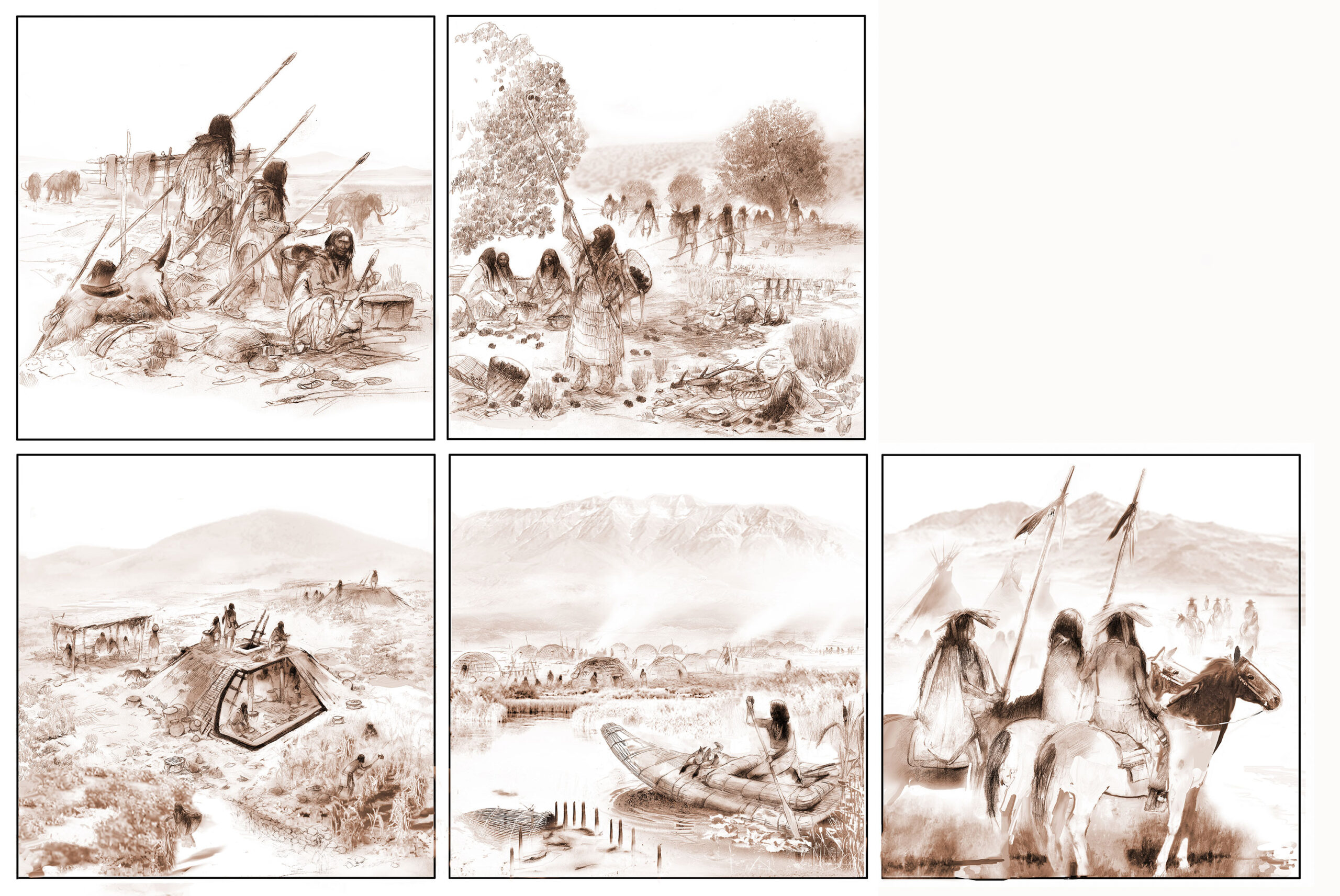
Timeline of Precontact cultures in the Salt Lake Basin, completed for an exhibit display at the Antelope Island State Park Visitors Center, Utah: (1) Paleoindian mammoth hunters, (2) Archaic Period pinenut harvesting, (3) Fremont pithouse and ramada, (4) Late Archaic village with tule boat and fish trap in foreground, (5) Historic period meeting between the son of Chief Wanship and members of John C. Fremont’s expedition on the shore of Antelope Island (by Eric Carlson).
Material Culture Illustration
We produce publication-quality artifact and specimen illustrations in the medium that best suits your needs.
Material Culture Illustration
We produce publication-quality artifact and specimen illustrations in the medium that best suits your needs.
Desert Archaeology staff can be contracted to visually record individual artifacts, biological specimens, or entire collections, as well as to create depictions of past lifeways. Available illustration methods include the pencil and/or ink drawings that are often required for mortuary artifacts, high-resolution digital scanning, and digital and film photography.
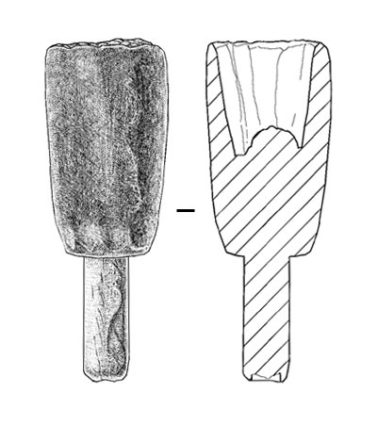
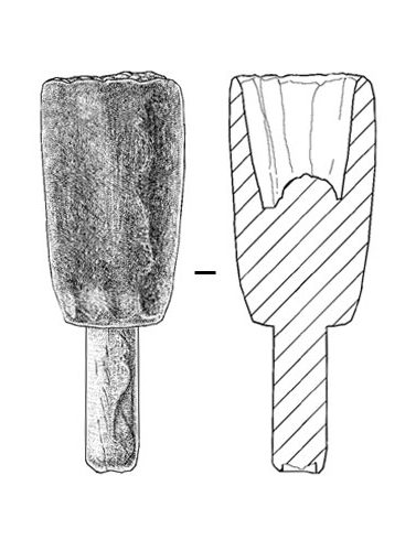
Robert B. Ciaccio also has more than 15 years of experience photographing and hand-illustrating artifacts of all material types. On request, he can create roll-out views of ceramic designs, as well as profiles extrapolated from partial vessels.
Eric S. Carlson is a project director and illustrator for Desert Archaeology. He specializes in technical artifact illustrations, field renderings of archaeological and architectural features, rock art documentation, site reconstructions, and museum exhibit displays. He has worked as an on-site illustrator at Pre-pottery Neolithic and Early Bronze Age sites in Jordan, at early monastic sites in Ireland, and recorded rock art in remote regions of Alaska. His more local work has focused on illustrating decorated ceramic vessels, shell ornaments, and ground stone objects from Hohokam sites in the Phoenix Basin. He utilizes a variety of illustrative styles and is adaptable to the unique demands a client may have of conveying information visually.
Click here for his blog post on illustrating Hohokam decorated ceramics.
Gallery (click to enlarge and zoom)
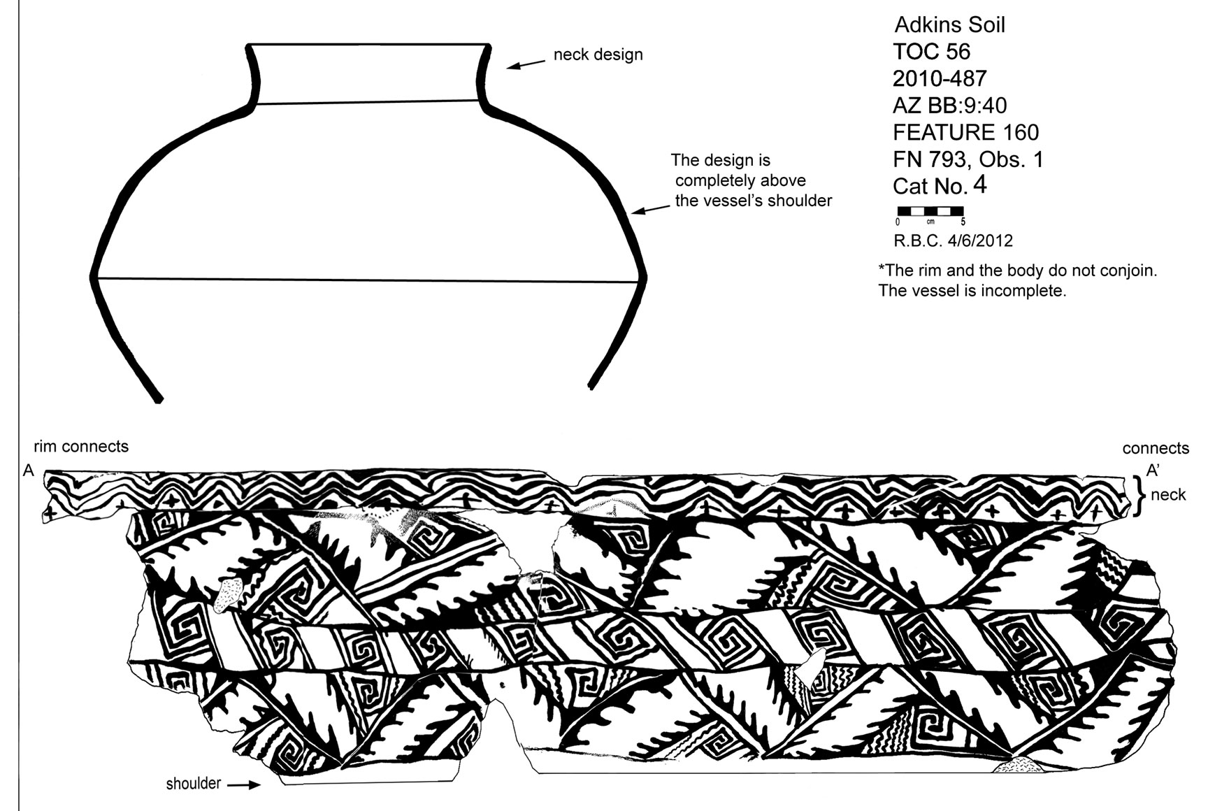
Rollout illustration of design on Hohokam vessel from site near Fort Lowell, Tucson, by Robert Ciaccio.
Corn cob from Las Capas, Tucson, by Robert Ciaccio.

Historic era projectile points from the Gila River Indian Community, by Robert Ciaccio.
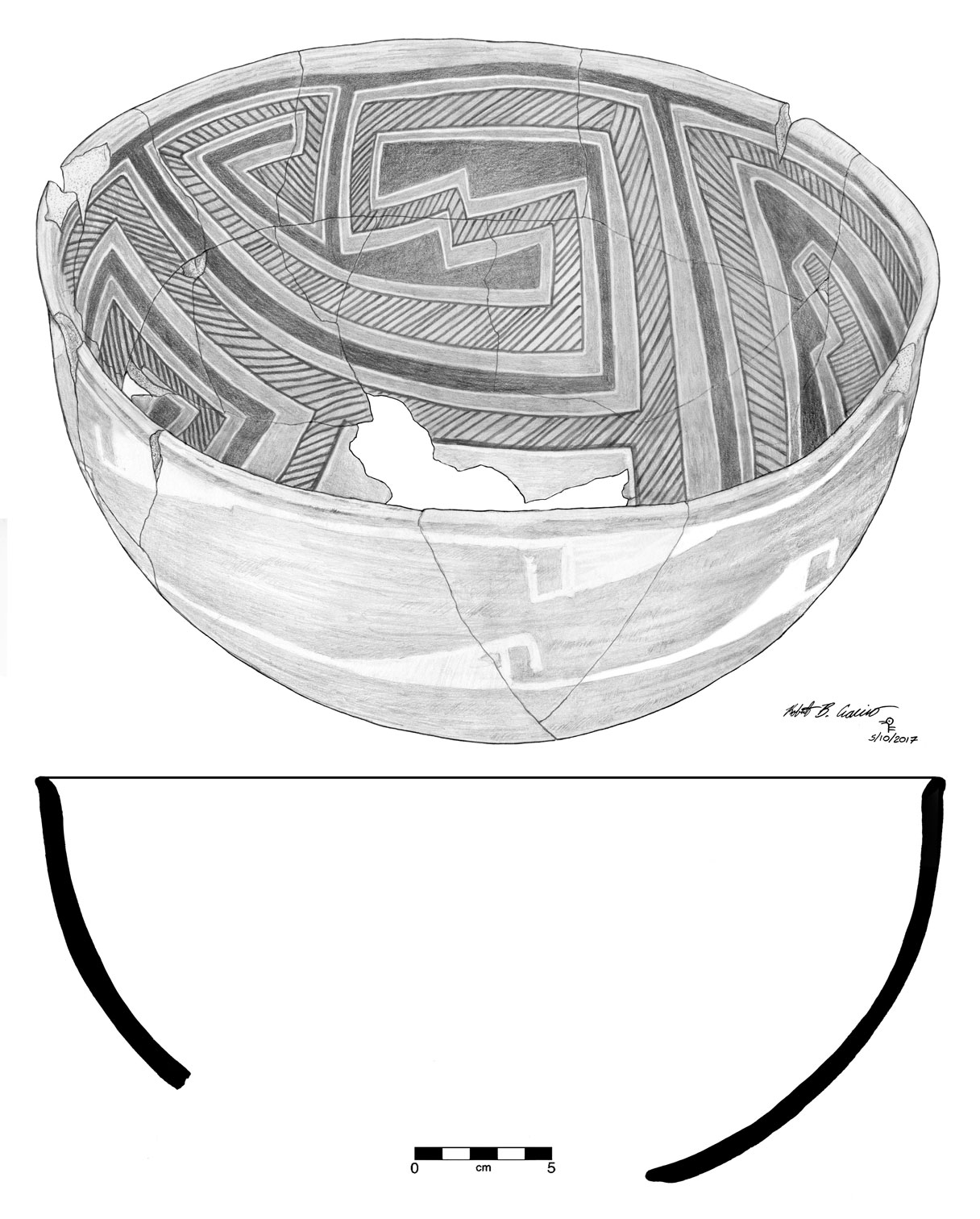
Polychrome bowl from Point of Pines, San Carlos Apache Indian Reservation, by Robert Ciaccio.
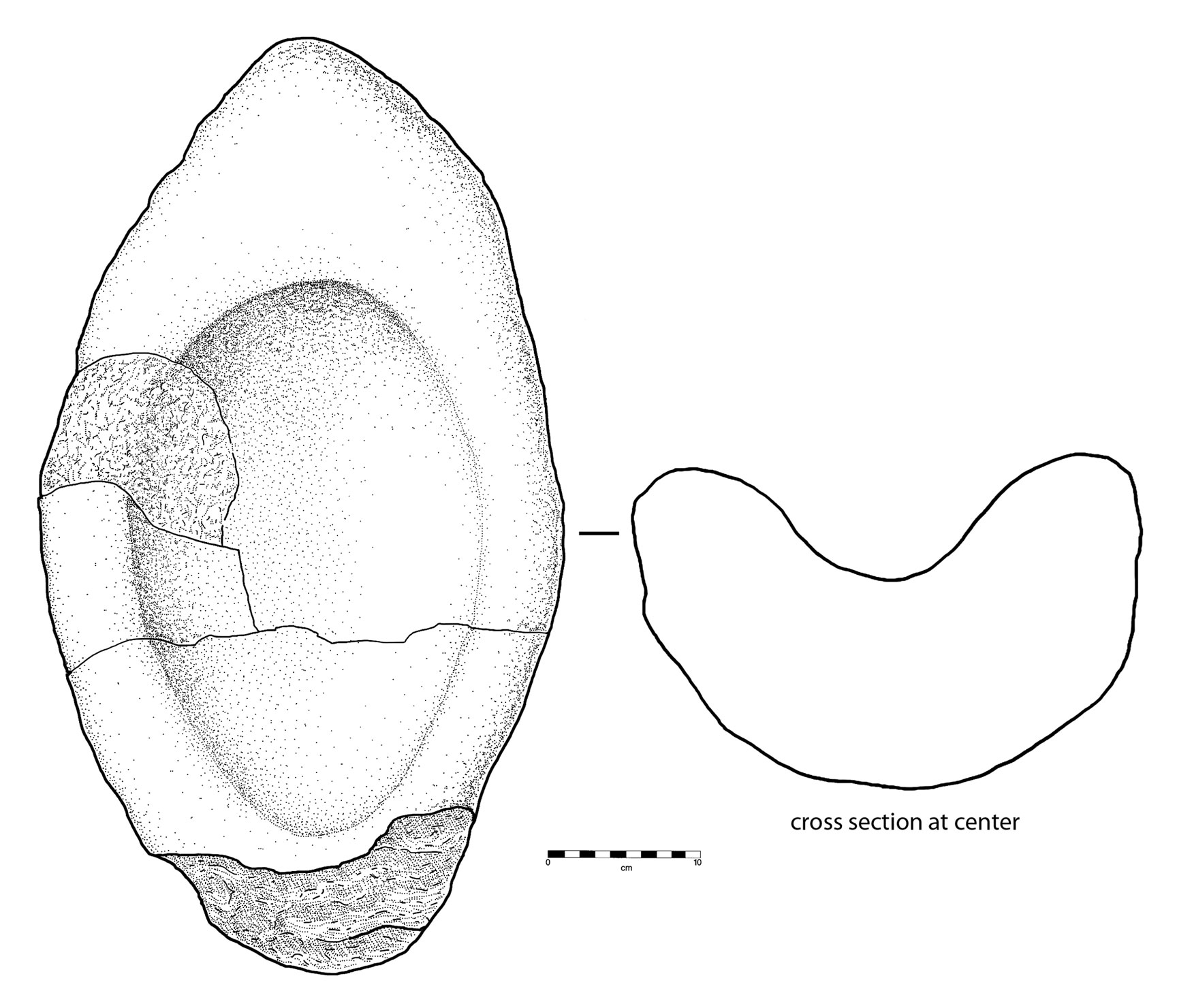
Basin metate from a site near San Isidro, Arizona, by Robert Ciaccio.

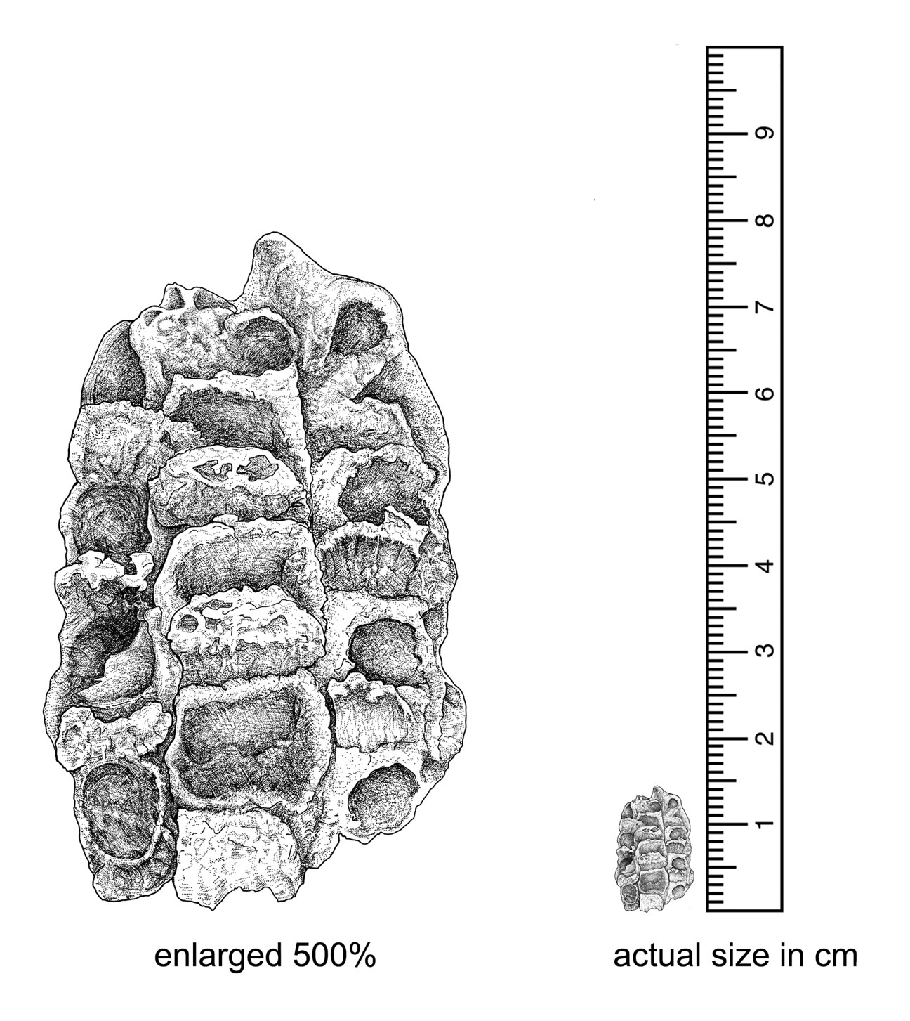
Hohokam basket fragments from the Yuma Wash site, Tucson, by Robert Ciaccio.
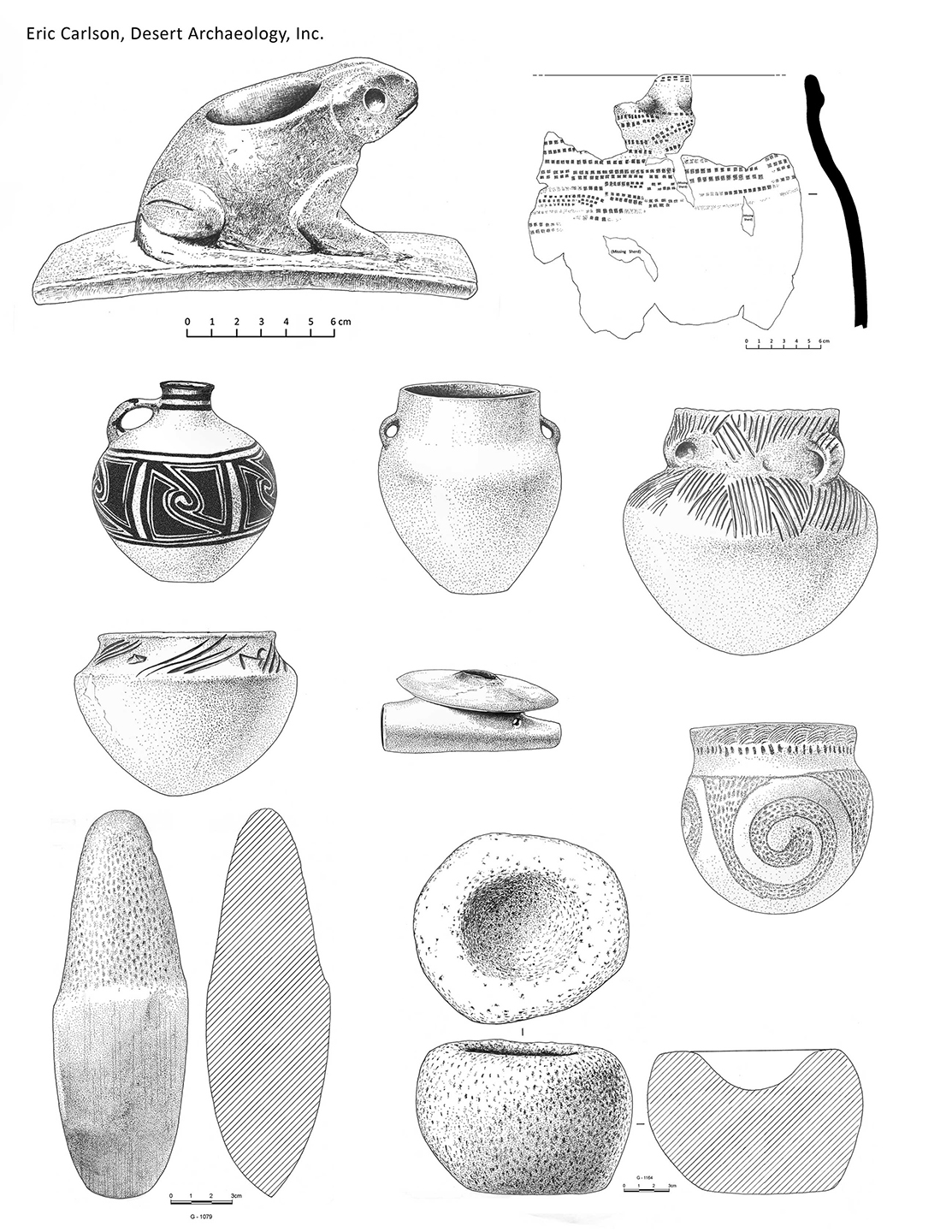
Ceramic vessels and groundstone pipes from the North American Great Plains (published in The Archaeology of the North American Great Plains, by Douglas B. Bamforth, Cambridge World Archaeology, 2021). Pre-pottery Neolithic hand axe and stone bowl from the 12,500 year old site of Dhra’, Jordan (by Eric Carlson).
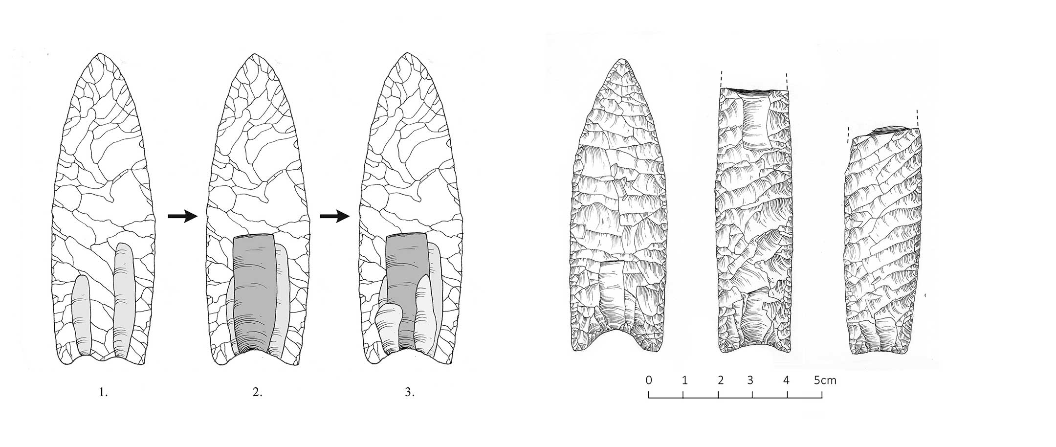
Flaking stages to remove channel flake on a Paleoindian Clovis point (left). Three Clovis spear points showing basal variation (by Eric Carlson).
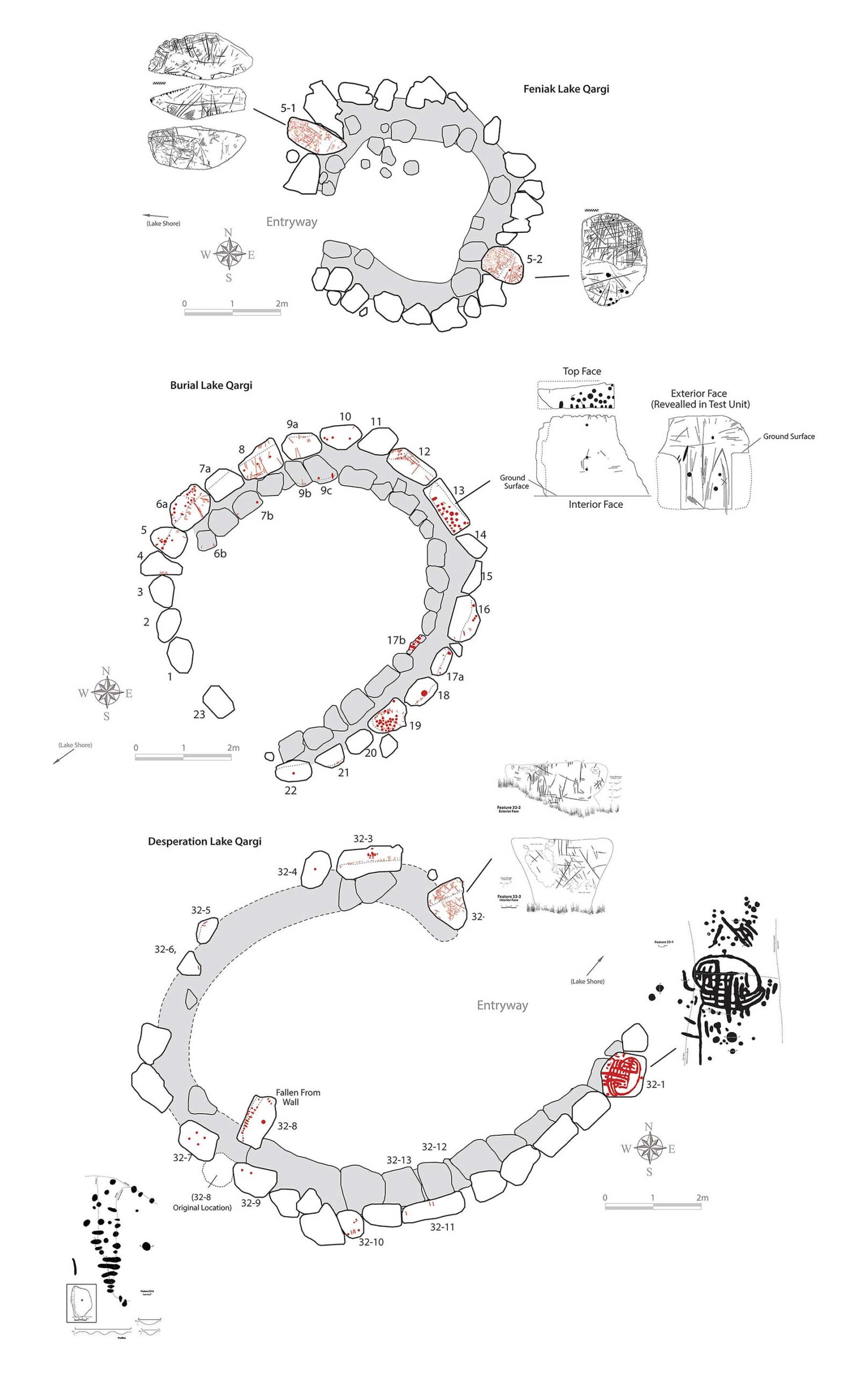
Petroglyphs shown in spatial context within three boulder-lined communal structures at Late Precontact lakeside settlements in the Western Brooks Range, Alaska (published in Iñupiaq Cultural Complexity as Viewed from Three Late Prehistoric Lakeside Settlements in the Western Brooks Range, by Scott Shirar, Jeff Rasic, Eric Carlson, and Sam Coffman. University of Alaska Museum of the North and the National Park Service, 2025).
Contracting information:
Contact us to contract artifact illustration services or to inquire about licensing fees for existing artwork.
Mapping
Maps are invaluable for placing your information into a spatial context your readers, clients, or customers can easily understand. We create visually compelling maps that seamlessly integrate geography with planning and analytical data at any scale. Whether your map will cover the endpapers of a coffee table book, or illustrate an online article, we shape the design to reflect the context of your publication.
We specialize in visualizing land use, from minimalist maps showing site locations and major natural features to maps showing the intricate curves of streambeds, and mountains and valleys in color-shaded relief. We can produce maps with underlays of georeferenced historical maps (Sanborn Fire Insurance maps, General Land Office survey plats), USGS topographic maps of all scales, orthoimagery (from Google Earth or any other source), hillshaded relief (with customized colorization), street and highway data, municipal and county boundaries, topographic contour lines, and original illustrations.
Do you need to query a spatial dataset to verify objectives or discover fresh insights into research possibilities? Provide us your tabular attribute data and spatial entities (mapping or location data as points, lines or polygons) and we will build a GIS project for your queries. Results can be delivered in a wide variety formats.
No starter map or GIS data? No problem. Our mapping team provides full cartographic, GIS, and aerial photogrammetry services that seamlessly coordinate with our graphics production process. We design flexible strategies to meet project-specific needs with a high-precision system that can incorporate either ground-based or uncrewed aerial vehicle (UAV) airborne mapping techniques.
Examples of maps
- Location maps | Choose your scale: hemispheric, national, state, county, municipal, tribal reservation, project site, eco-zone, commercial area of interest.
- Research study area maps | Large regions and small detailed views of any place in the world can be created with your choice of background.
- Archaeological site maps | Go beyond clunky software templates and colors not found in nature. Have your site professionally digitized for details at any scale and allow your figures to be pleasingly informative.
- Archaeological feature maps and profiles | Plan views and cross-sections are drawn to standardized conventions of your choosing.
- GIS analysis | You provide the data, we’ll create a GIS you can query, and then we’ll work together to produce your results in formats you can use.
- Orthophotography and underlays | Orthoimages, or georeferenced aerial views, have become essential in municipal projects as well as in spotting archaeological features on barren landscapes. A bird’s eye view places the reader just above the scene and orients their perspective.
- Geological maps | Draping the boundaries of geological units over the terrain of a large region can identify the originating sources of specific minerals found in pottery temper. But you might have other reasons, besides petrographic analysis, for wanting to know the geology of an area. We can help.
- Planning and analysis maps | When stakeholders prepare documents for planning purposes, a series of maps can show steps already taken and outline future plans of action. When researchers need to exhibit the results of analysis over time and space, there’s no better way to show their discoveries than with maps.
- Tourist/visitor/conference maps | Show people where to go and what they might find along the way. These maps can be provided in a variety of formats.
Gallery (click to enlarge and zoom)
For purposes of archaeological site preservation, site names and detailed views of “at risk” site locations have been obscured or removed from online illustrations. To discourage the copying of online images, the resolution of each image has been reduced, and translucent watermarks of the words “Desert Archaeology, Inc.” may have been superimposed.
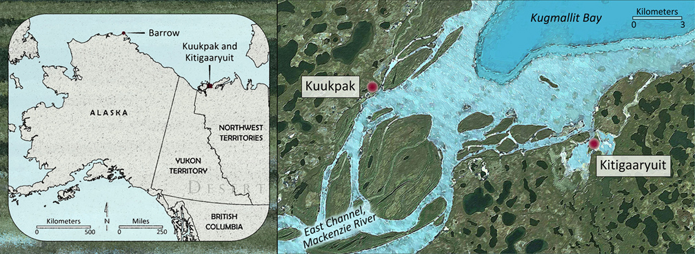
Draft of Arctic village locations done in a requested “watercolor” style (by Catherine Gilman). Prepared for and used with the permission of sapiens.org.
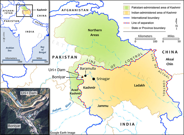
An illustration for an article on Kashmir, with a map of the area of concern, an inset of the greater area, and an annotated Google Earth image (by Catherine Gilman). Prepared for and used with the permission of sapiens.org.
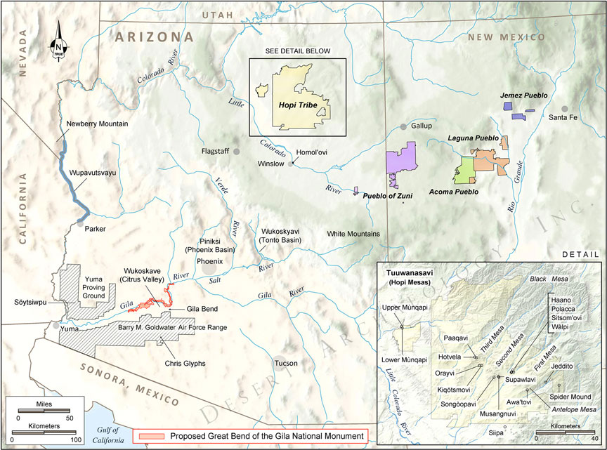
Low relief on an overview map and high-definition relief on a detail for a figure within a proposal for the designation of Great Bend of the Gila National Monument (by Catherine Gilman).
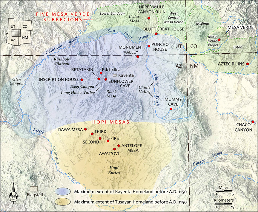
Ancient homelands in the Four Corners region on high-definition hillshaded relief, for Archaeology Southwest Magazine (by Catherine Gilman).
A site map with topographic contours, for Archaeology Southwest Magazine (by Catherine Gilman).
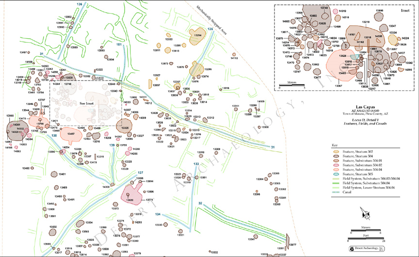
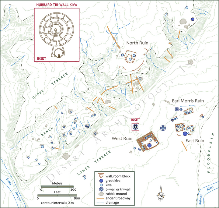
Archaeological features by stratum at Las Capas, Arizona, with detail inset, for Anthropological Paper No. 50 (by Catherine Gilman).
Archaeological Feature Maps and Profiles
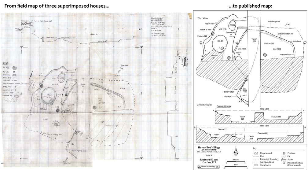
A scanned hand-drawn vellum field map from Honey Bee Village, Arizona, showing three superimposed pithouses in plan view with two cross-sections, and the resulting published figure in Desert Archaeology’s Anthropological Paper No. 48 (by Catherine Gilman).
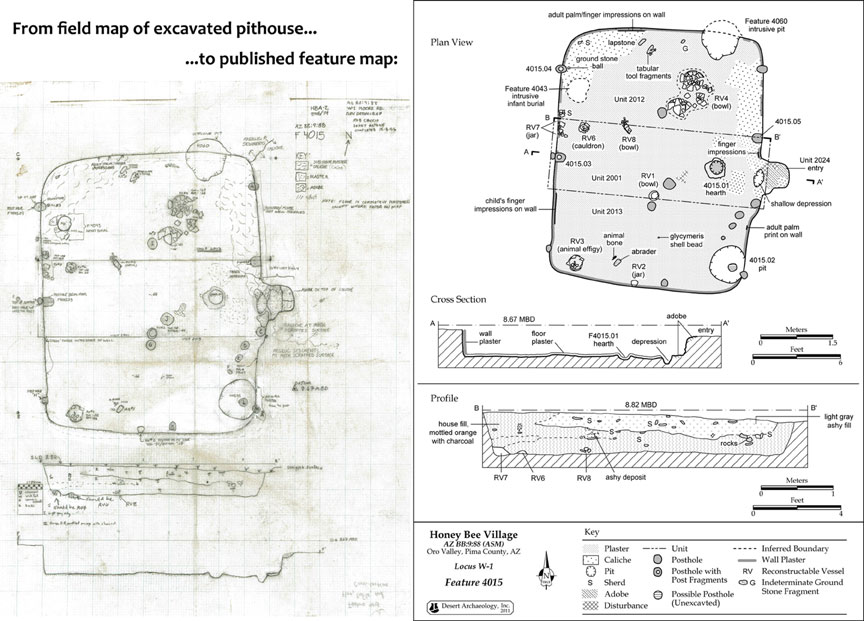
The transformation of a hand-drawn plan view of a pithouse at Honey Bee Village to the final version published in Desert Archaeology’s Anthropological Paper No. 48 (by Catherine Gilman).
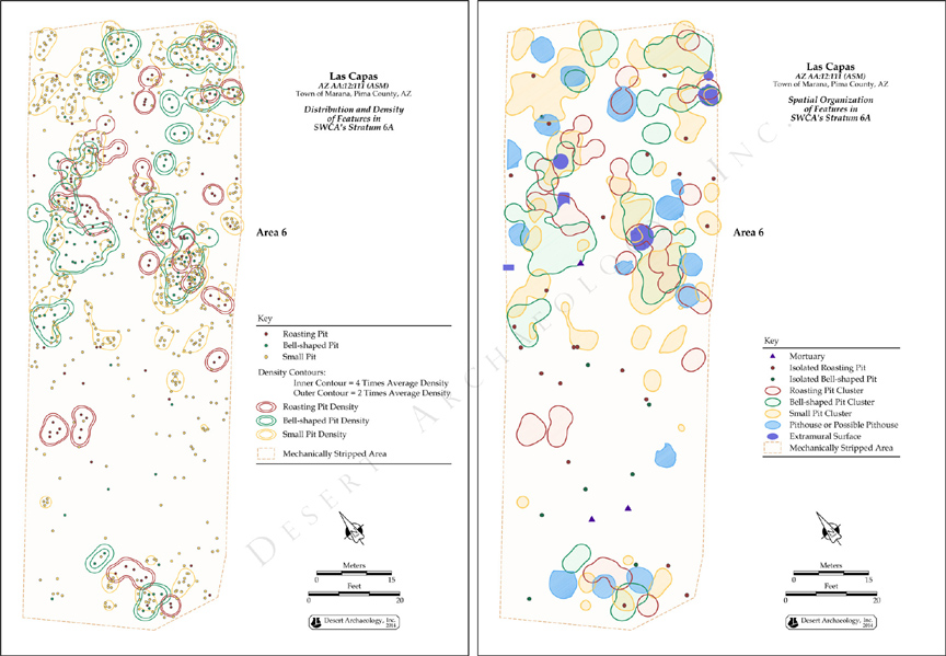
Two examples of GIS analyses (density contours and the spatial organization of clustered features by type) of archaeological features at Las Capas, Arizona, published in Desert Archaeology’s Anthropological Paper No. 50 (by Catherine Gilman).
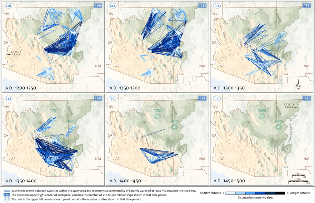
Large region spatial connectivity analysis showing site proximity and commonality of ceramic wares through time, for Archaeology Southwest Magazine (by Catherine Gilman).
Orthophotography and Underlays
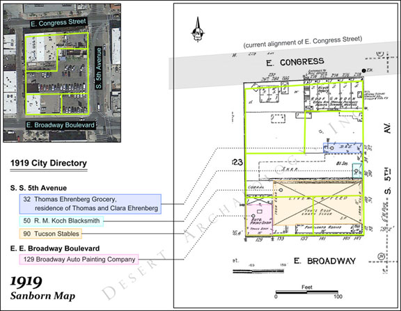
Outline of parcels on an annotated 1919 Sanborn Fire Insurance map and a Google Earth image, published in a historical archaeology technical report on excavations of a city block in Tucson (by Catherine Gilman).
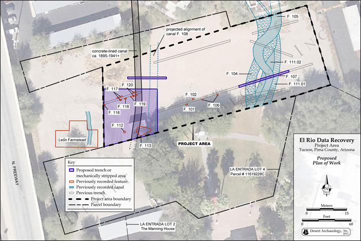
Orthoimagery underlying translucent features for a proposed plan of work for a city block in Tucson (by Catherine Gilman).
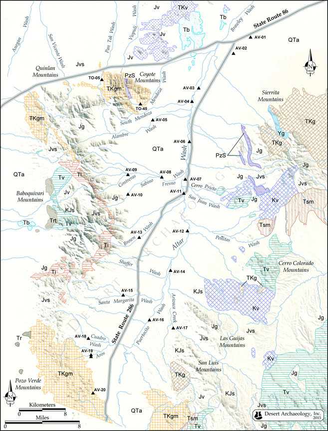
Sand sample locations and geological units on hillshaded relief, for an Arizona petrofacies report (by Catherine Gilman).
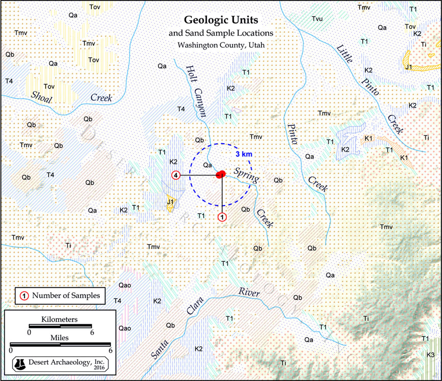
Sand sample locations and geological units on hillshaded relief, for a Utah petrofacies report (by Catherine Gilman).
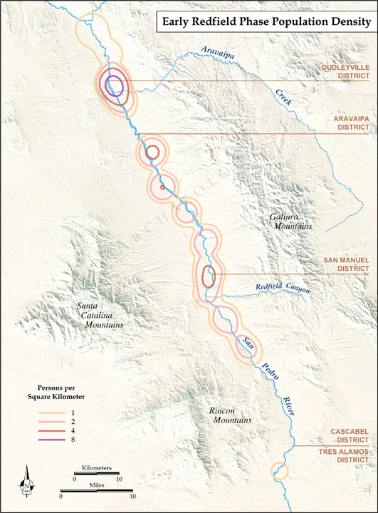
Population density analysis for a particular phase of San Pedro River valley occupation, for Anthropological Paper No. 45 on the San Pedro River, Arizona (by Catherine Gilman).

Map locating the proposed Modern Streetcar alignment through Tucson, with historic districts, for an intensive study of existing buildings along the route for a City of Tucson planning document (by Catherine Gilman).
Tours, Brochures, and Endpapers
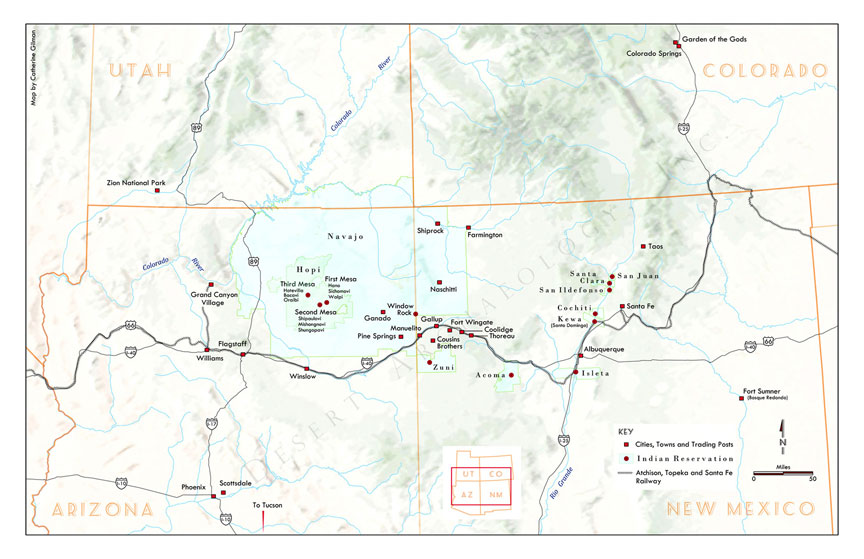
Map of the Four Corners region used as front and back endpapers for a large-format book (by Catherine Gilman).
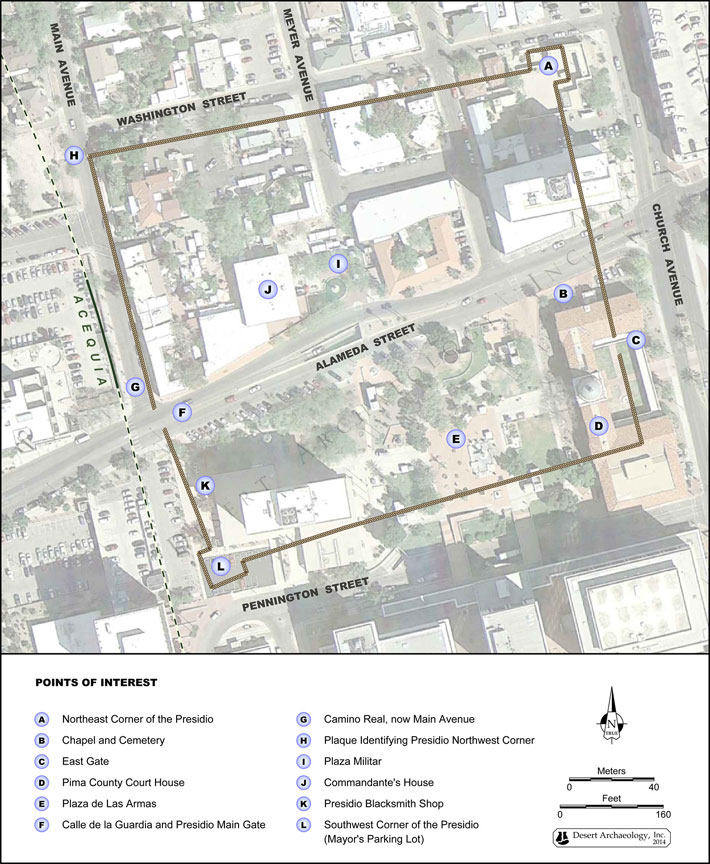
Tour guide map for the 1776 Tucson Presidio area superimposed on muted orthoimagery showing modern architecture (by Catherine Gilman).
Contracting information:
Contact us to arrange a consultation for your map production needs.