
This Old House Group: Residential Permanence During the Early Cienega Phase
“Old” may only be 30-50 years. That’s still pretty cool. 2,500 years is cooler. Erina Gruner discusses spatial patterns in Tucson Basin early agriculturalist pithouse settlements during the Cienega phase, and what the grouping of houses and burials into “house groups” tells us about mobility, social organization, and land ownership.
Most archaeology in an urban setting is done in small pieces, and the big picture emerges over time. Over the past 20 years, Desert Archaeology has excavated numerous areas of Los Pozos (AZ AA:12:91[ASM]), an extensive Early Agricultural period (2100 BC-AD 50) site lying under Interstate 10 in northwest Tucson. Work has been conducted as “salvage archaeology” for various infrastructure improvements. Each excavation reveals a new piece of this pre-ceramic settlement, which was occupied repeatedly over the course of about 3,600 years. 2019-2020 excavations for the Ruthrauff Road Interstate 10 overpass uncovered new habitation areas and agricultural fields, which date primarily to the Early Cienega phase (800-400 BC). This period was an important “in between” phase that bridged the gap between the relatively mobile, dispersed settlement patterns that preceded it in this area, and the aggregated, more permanent settlements that followed.
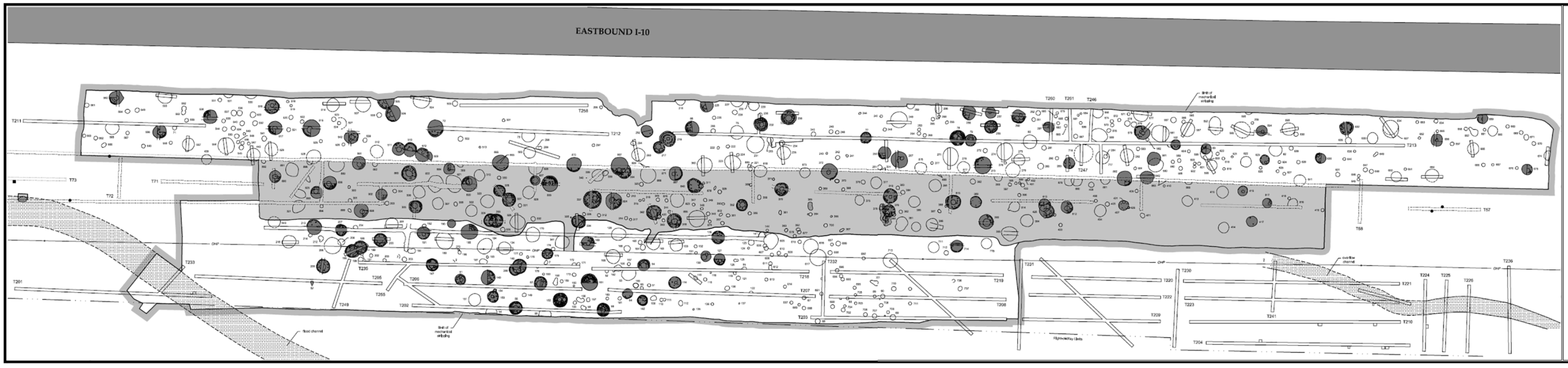
At the recently excavated “Big Tex” locus of Los Pozos, eighteen Early Cienega pit structures clustered into eastern and western house rings, each with a shared cemetery and an open central activity area.

Map of the eastern and western house groups and cemeteries at the Big Tex locus of Los Pozos. Click to enlarge.
Structures appear to have been repeatedly rebuilt in the same ring-like pattern, likely through many seasonal occupations. These “house groups” show how during the Early Agricultural period, extended families began to transfer land and resources across generations, as additional labor was expended in developing irrigation systems.
The Big Tex locus is located on the Santa Cruz River floodplain, in an area that would have been very attractive to prehistoric irrigation agriculturalists. Contemporaneous field plots immediately north of the Big Tex locus indicate that Big Tex was an agricultural farmstead that likely was seasonally occupied.
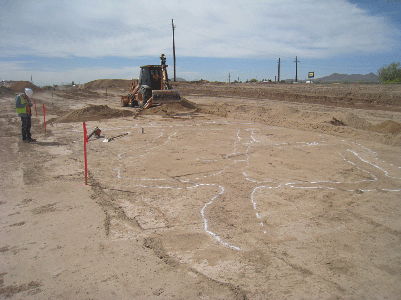
Early Cienega agricultural fields under the southbound I-10 frontage Road are exposed with a backhoe. The berms and feeder canals of “waffle garden” fields are outlined with spray paint so that they can be mapped. Photo by Greg Whitney. Click to enlarge.
The settlement lay in a rich riparian (riverbank) zone, which provided valuable fuel wood and other valuable plant and animal resources. Phytoliths (microscopic fossilized silica from decomposed plants, used to identify plant species) tell us that people built their grass-thatched pithouses here mostly during the spring and early summer, with some construction during the late summer or fall. Each pit structure was probably occupied for only a few years before it was left to decompose. However, their uselives could be extended with repairs; Allen Denoyer of Archaeology Southwest reports that experimental replica pithouses last a decade or more, if the thatch and support posts are regularly replaced.
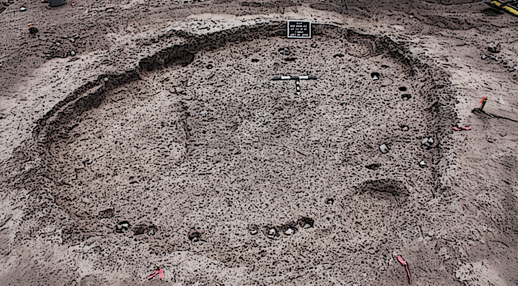
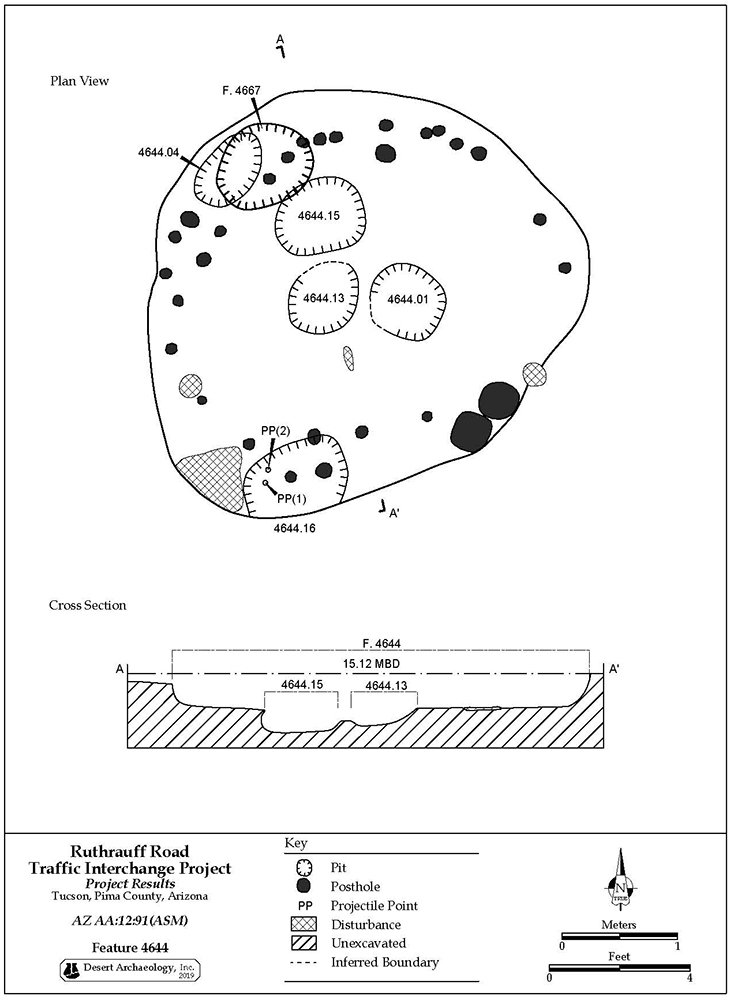
At Big Tex, we see both larger structures with features like prepared floors, adobe walls, and hearths—interpreted as houses people lived in—and smaller, more ephemeral pit structures that may have been used for storage. These cluster within house rings, with “storage” structures placed between or behind relatively evenly spaced residences. Groupings of residences and storage structures within the ring may belong to individual nuclear families.
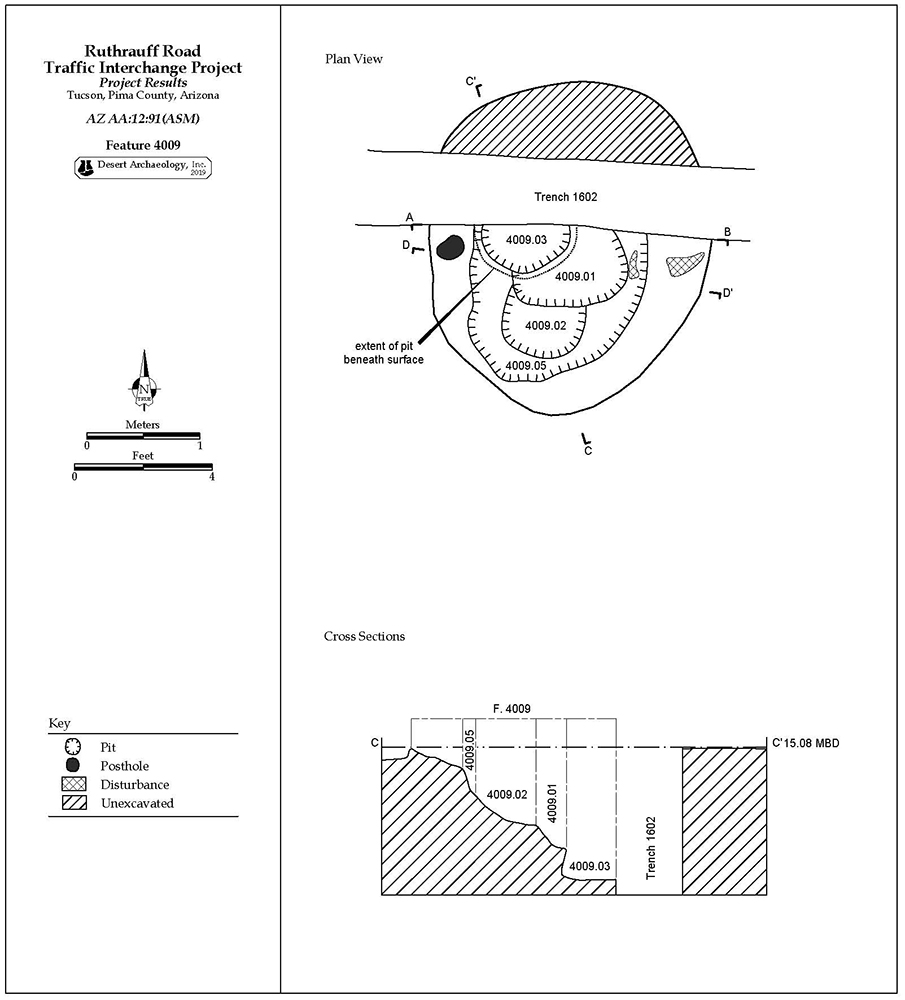
Each house ring at Big Tex is also surrounded by a ring of pits. Some cut into older houses, indicating that despite the even spacing of pit structures, not every structure was used simultaneously. Most of these pits were probably used in various processing activities. Bell-shaped pits (dug with narrow openings but expanding with depth, creating a bell-shaped cross section) in the project area consistently contained great quantities of diverse materials like fire cracked rock, flaked and ground stone tools, and other debris. This is probably because the pits provided a convenient location for waste disposal after processing activities that occurred around them were concluded.
A small number of very deep and bell-shaped pits may have first been used for food storage—with the caveat that substantial limitations exist on what types of foods can be stored in subterranean pits. Early Agricultural pits flooded frequently, which is a poor condition for storing viable seed corn, or dry goods generally. However, it may have been perfect for producing something similar to “kanga pirau,” (“rotten corn”)—a Maori fermented delicacy described as “a corn-based porridge that happens to smell like vomit.” Although this may not have universal gastronomical appeal, fermented green maize can be stored underground for weeks to months. Were Early Ag people literally digging their fermented foods? Time (or chemical testing) may yet tell. However, we do know the ground stone tools they used were better suited to processing mushy corn than hard dried kernels.
For the most part, neither residences nor storage structures at Big Tex appear to have been used for very long before they were abandoned. However, both types of structure were sometimes repeatedly remodeled.
Overlapping post holes and small pits in a repeatedly remodeled residential structure.
Overlapping large storage pits in a repeatedly remodeled storage structure.
In a handful of instances, residential structures were completely replaced with new houses at the same location within the house ring. Interestingly, the residential structures that were most frequently remodeled, or that were replaced with other structures, show ritual behaviors related to important points in their “life cycles”—for instance, the burial of ornaments and other objects under the floor, and likely the burning of the house when it was finally abandoned. Both house rings have examples of these replaced or heavily remodeled residences.
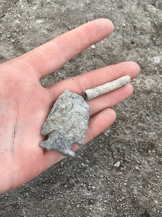
Bone tube and projectile point buried in a sealed floor pit in a Los Pozos pit structure. The projectile point style is older than the house, and was probably already an heirloom or artifact when it was buried. Photo by Erina Gruner.
We think that each house ring likely corresponds to an extended family that was related by blood or marriage, with a variable number of structures simultaneously occupied based on the shifting demographics of each family group. Modelled radiocarbon dates indicate that they probably resided at Big Tex for one or two generations, between approximately 585 and 375 B.C. However, several lines of evidence suggested that the population of Big Tex was not permanently resident at the locus during this entire time, and may in fact have moved back and forth between different habitation areas on a fairly regular basis.
The clearest evidence of this comes from the cemeteries associated with each house group: a quarter or more of the human remains were people that were originally interred at another location, but were later brought to the site as bone bundles. There were also more ancestral remains present in each cemetery than would be expected based on both the number of houses present and the estimated rate of house replacement. This indicates that Early Agricultural people likely continued to place their ancestors in family cemetery plots, even when they were living at other locations.
House rings similar to the ones at Big Tex have been documented at several other Cienega phase sites, including Santa Cruz Bend and the Wetlands site along the Santa Cruz River, and the Kearny Site along the Gila River. One of these sites, Wetlands, is geographically close enough and structurally similar enough to Big Tex that it may have been used by the same population, as they moved back and forth along the Santa Cruz River. These types of local movements were documented among the historical O’odham people who farmed this area, and who shifted their villages frequently according to changing environmental conditions.
The house rings at Big Tex were very different than in the earlier habitation loci at Los Pozos—which tend to have a small number of widely dispersed houses—and also different from the Late Cienega phase (400 BC-AD 50) habitation that followed in the Central Cluster locus to the south, which had hundreds of overlapping, haphazardly placed pit structures crowded into a single habitation zone that was occupied for over a hundred years. If house rings were present in this Late Cienega locus, they would not be obvious; so much crowding obscures spatial patterns.
Late Cienega phase habitation area at Los Pozos, showing crowded structures from repeated reoccupation of the area. Click to enlarge.
Significantly, most Early Cienega phase sites that have been excavated to date also did not have house rings. This probably says something about the enormous flexibility in how Early Agricultural people organized themselves. Cross-culturally, very formal and segmented spatial arrangements like house groups are most prevalent where valuable estates (like agricultural land) are passed down within families, particularly families that accumulate power through formal patterns of marriage alliance. In these same cultures, less powerful families that do not inherit valuable land often show a more haphazard patterns of house placement.
We do know that the occupants of Big Tex appear to have been particularly well connected in their time and place. For example, more shell and obsidian artifacts were found here than in any contemporaneous site, indicating that they were big players within regional exchange networks. The eastern house group, which appears to be the founding population of Big Tex, had significantly more obsidian, and also the most valuable shell artifact (an elaborate shell necklace with over a thousand dentalium and abalone shell beads).
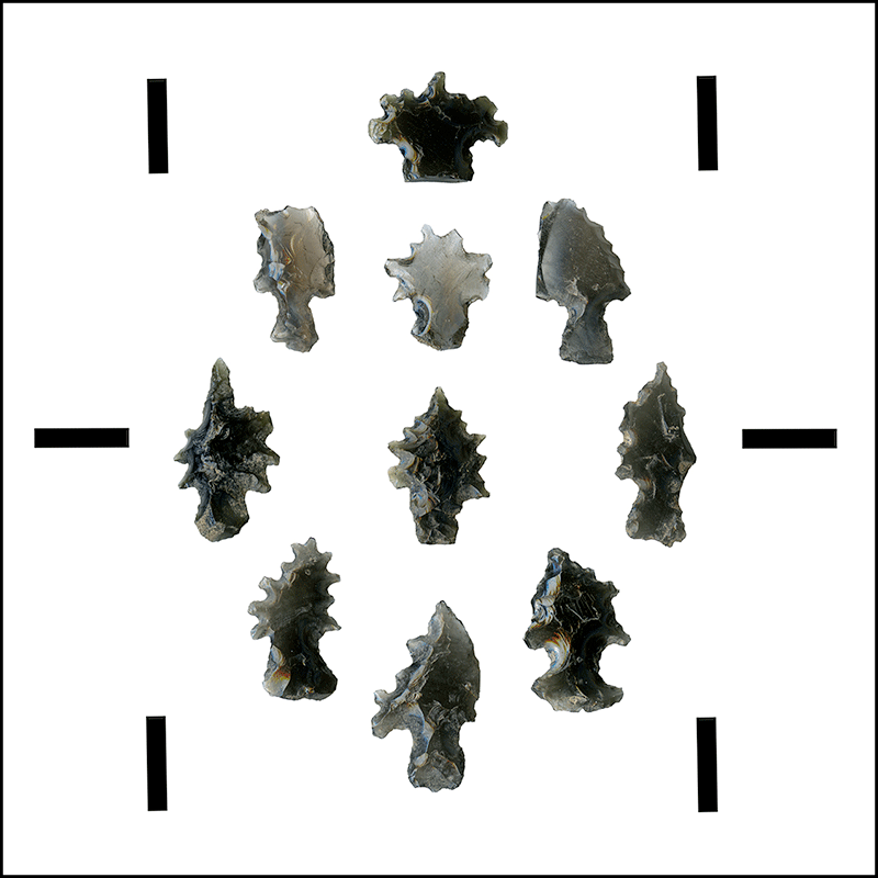
Unusual obsidian artifacts from the eastern house group at Big Tex. Scale bars are 1 centimeter. Photo by RJ Sliva.
By the beginning of the Late Cienega phase (c. 400 BC), social or environmental conditions at Los Pozos shifted, and the Big Tex locus was mostly abandoned. These families may have relocated to the large Late Cienega phase habitation locus to the south. However, more of their fields and houses likely still lie under Interstate 10.